IMAGES TAKEN NEAR TO
Station Road, KIDWELLY, SA17 4UT
Introduction
This page details the photographs taken nearby to Station Road, SA17 4UT by members of the Geograph project.
The Geograph project started in 2005 with the aim of publishing, organising and preserving representative images for every square kilometre of Great Britain, Ireland and the Isle of Man.

There are currently over 7.5m images from over14,400 individuals and you can help contribute to the project by visiting https://www.geograph.org.uk
Image Map
Images are licensed for reuse under creativecommons.org/licenses/by-sa/2.0
Notes
- Clicking on the map will re-center to the selected point.
- The higher the marker number, the further away the image location is from the centre of the postcode.
Image Listing (156 Images Found)
Images are licensed for reuse under creativecommons.org/licenses/by-sa/2.0
Image
Details
Distance
1
Ysgol Gymraeg Cydweli - Kidwelly Welsh School
Image: © Eirian Evans
Taken: 24 May 2022
0.03 miles
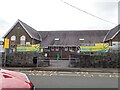
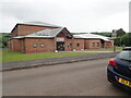
2
Ysgol Gwenllian, Kidwelly
Welsh language primary school in Station Road.
Image: © Jaggery
Taken: 29 Mar 2013
0.04 miles
3
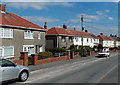
Station Road houses, Kidwelly
Viewed from near the Park View Drive corner looking towards the Westhill Crescent junction.
Image: © Jaggery
Taken: 29 Mar 2013
0.04 miles
4
Busy Bugs Day Nursery in Kidwelly
Located in The River Lodge on the north side of the road named Hillfield Villas.
Image: © Jaggery
Taken: 29 Mar 2013
0.07 miles
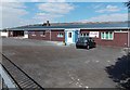
5
Kidwelly Fire Station
On Quay Road, near the Princess Gwenllian Centre
Image: © Eirian Evans
Taken: 23 May 2022
0.07 miles
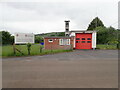
6
Kidwelly Fire and Rescue Station
Part of the Carmarthenshire Command of the Mid and West Wales Fire and Rescue Service, located on the north side of the street named Hillfield Villas. The station covers the town of Kidwelly and the neighbouring communities of Llansaint, Ferryside, Llandyfaelog, Mynydd y Garreg and Pembrey.
Image: © Jaggery
Taken: 29 Mar 2013
0.08 miles
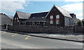
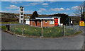
7
Late Victorian building in Hillfield Villas, Kidwelly
Viewed across the street named Hillfield Villas. There was no name sign, only an inscription showing BUILT 1885. Morfa Chapel is in the background, so perhaps this used to be its Sunday School.
Image: © Jaggery
Taken: 29 Mar 2013
0.08 miles
8
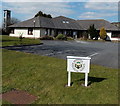
Minafon Surgery, Kidwelly
The doctors' surgery is set back from the street named Hillfield Villas. Minafon is Welsh for river's edge, which perfectly describes this location on the south bank of the River Gwendraeth (Gwendraeth Fach branch). The Fire and Rescue Station http://www.geograph.org.uk/photo/3914381 tower is in the background.
Image: © Jaggery
Taken: 29 Mar 2013
0.08 miles
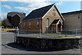
9
Canolfan Tywysoges Gwenllian
Opened in May 2001, this is the venue for concerts, meetings, functions and sporting events.
Image: © Eirian Evans
Taken: 23 May 2022
0.09 miles
10
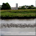
Rivebank view of Kidwelly fire station tower
Located here. http://www.geograph.org.uk/photo/3914381 Viewed across the River Gwendraeth (Gwendraeth Fach branch)
from the Wales Coast Path. The extent of the mud shows the tidal range of the river.
Image: © Jaggery
Taken: 16 Jul 2015
0.09 miles