IMAGES TAKEN NEAR TO
Westhill Crescent, KIDWELLY, SA17 4US
Introduction
This page details the photographs taken nearby to Westhill Crescent, SA17 4US by members of the Geograph project.
The Geograph project started in 2005 with the aim of publishing, organising and preserving representative images for every square kilometre of Great Britain, Ireland and the Isle of Man.

There are currently over 7.5m images from over14,400 individuals and you can help contribute to the project by visiting https://www.geograph.org.uk
Image Map (Loading...)


Getting Data...Please wait
Leaflet Map data © OpenStreetMap
Images are licensed for reuse under creativecommons.org/licenses/by-sa/2.0
Notes
- Clicking on the map will re-center to the selected point.
- The higher the marker number, the further away the image location is from the centre of the postcode.
Image Listing (139 Images Found)
Images are licensed for reuse under creativecommons.org/licenses/by-sa/2.0
Image
Details
Distance
1
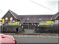
Ysgol Gwenllian, Kidwelly
Welsh language primary school in Station Road.
Image: © Jaggery
Taken: 29 Mar 2013
0.04 miles
2
Ysgol Gymraeg Cydweli - Kidwelly Welsh School
Image: © Eirian Evans
Taken: 24 May 2022
0.04 miles
3
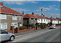
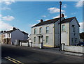
Station Road houses, Kidwelly
Viewed from near the Park View Drive corner looking towards the Westhill Crescent junction.
Image: © Jaggery
Taken: 29 Mar 2013
0.07 miles
4
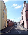
Eastern end of Station Road, Kidwelly
Viewed from Bridge Street near the point where it becomes Causeway Street.
Kidwelly railway station is about 650 metres ahead.
Image: © Jaggery
Taken: 29 Mar 2013
0.09 miles
5
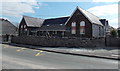
Late Victorian building in Hillfield Villas, Kidwelly
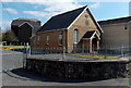
Viewed across the street named Hillfield Villas. There was no name sign, only an inscription showing BUILT 1885. Morfa Chapel is in the background, so perhaps this used to be its Sunday School.
Image: © Jaggery
Taken: 29 Mar 2013
0.10 miles
6
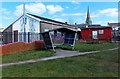
Sheltered seating at the edge of Parc Stephens in Kidwelly
Parc Stephens is the home ground of Kidwelly RFC (Rugby Football Club).
Image: © Jaggery
Taken: 29 Mar 2013
0.10 miles
7
Orchard Villa, Kidwelly
Located in Station Road near the post office. http://www.geograph.org.uk/photo/3914645
In the early 21st century here is widespread apprehension about the loss of various aspects of personal privacy because of information freely available on the Internet. It is interesting therefore to see the information published in the Edwardian era. Kelly's Directory of Kidwelly, 1906 edition, states that Orchard Villa, Station Road, was the residence of Evan V. Davies, a cattle inspector for the Great Western Railway. Was this information taken from the UK Census of 1901?
Image: © Jaggery
Taken: 29 Mar 2013
0.11 miles
8
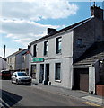
Kidwelly post office
Viewed across Station Road.
Image: © Jaggery
Taken: 29 Mar 2013
0.11 miles
9
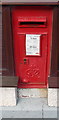
King George VI postbox in the wall of Kidwelly Post Office
Located here. http://www.geograph.org.uk/photo/3914645
Image: © Jaggery
Taken: 29 Mar 2013
0.11 miles
10
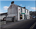
Kidwelly Post Office
At 3 Station Road near the corner of Bridge Street. There is a King George VI postbox http://www.geograph.org.uk/photo/3914648 in the wall.
Image: © Jaggery
Taken: 29 Mar 2013
0.12 miles