IMAGES TAKEN NEAR TO
KIDWELLY, SA17 4TH
Introduction
This page details the photographs taken nearby to SA17 4TH by members of the Geograph project.
The Geograph project started in 2005 with the aim of publishing, organising and preserving representative images for every square kilometre of Great Britain, Ireland and the Isle of Man.

There are currently over 7.5m images from over14,400 individuals and you can help contribute to the project by visiting https://www.geograph.org.uk
Image Map (Loading...)


Getting Data...Please wait
Leaflet Map data © OpenStreetMap
Images are licensed for reuse under creativecommons.org/licenses/by-sa/2.0
Notes
- Clicking on the map will re-center to the selected point.
- The higher the marker number, the further away the image location is from the centre of the postcode.
Image Listing (9 Images Found)
Images are licensed for reuse under creativecommons.org/licenses/by-sa/2.0
Image
Details
Distance
2
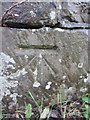
Ordnance Survey Cut Mark
This OS cut mark can be found on the north parapet of the railway bridge on Monksford Road. It marks a point 19.571m above mean sea level.
Image: © Adrian Dust
Taken: 2 Feb 2014
0.16 miles
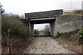
3
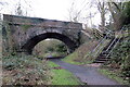
Hen bont reilffordd / Old railway bridge
Hen reilffordd, sy bellach yn llwybr ceffyl, yn mynd o dan bont sy'n cario'r B4308.
A former railway, today a bridleway, goes under a bridge which carries the B4308.
Image: © Alan Richards
Taken: 1 Feb 2021
0.16 miles
4
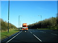
The B4308 meets the A484
View of the junction between the B4308 and the A484. The B4308 does actually continue on into Kidwelly at this staggered junction.
Image: © Stuart Wilding
Taken: 18 May 2008
0.16 miles
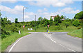
5
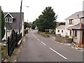
Monksford Street, Kidwelly
View downhill of Monksford Street, Kidwelly.
Image: © Jeremy Osborne
Taken: 16 Aug 2010
0.17 miles
7
Pont dros hen reilffordd / Bridge over a disused railway
Pont yn cario'r A484 yn rhychwantu hen rheilffordd.
A bridge carrying the A484 spanning a disused railway.
Image: © Alan Richards
Taken: 5 Feb 2021
0.22 miles
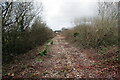
8
The Burry Port & Gwendraeth Valley Railway
The Burry Port & Gwendraeth Valley railway was built in the late 19th century primarily to carry coal from collieries in the Gwendraeth Valley. In 1909 it was officially converted to carry passengers (though it had done so illegally for a number of years previously). Passenger services eventually ended in 1953 but the line remained open to serve collieries until 1996 when it was closed. Tracks are still in place for most of its length from where it branches from the West Wales line to Cwm Mawr, though in many places the tracks are now completely covered with shrubs and weeds. This picture was taken off the A484 Kidwelly bypass.
Image: © Hywel Williams
Taken: 29 Nov 2006
0.23 miles
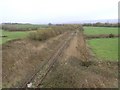
9
Hen reilffordd / Disused railway
Hen reilffordd yn mynd i gyfeiriad Cydweli.
A disused railway heading towards Kidwelly < Cydweli (trans. territory of Cadwal).
Image: © Alan Richards
Taken: 5 Feb 2021
0.23 miles