IMAGES TAKEN NEAR TO
Clos Yr Onnen, KIDWELLY, SA17 4ST
Introduction
This page details the photographs taken nearby to Clos Yr Onnen, SA17 4ST by members of the Geograph project.
The Geograph project started in 2005 with the aim of publishing, organising and preserving representative images for every square kilometre of Great Britain, Ireland and the Isle of Man.

There are currently over 7.5m images from over14,400 individuals and you can help contribute to the project by visiting https://www.geograph.org.uk
Image Map
Images are licensed for reuse under creativecommons.org/licenses/by-sa/2.0
Notes
- Clicking on the map will re-center to the selected point.
- The higher the marker number, the further away the image location is from the centre of the postcode.
Image Listing (6 Images Found)
Images are licensed for reuse under creativecommons.org/licenses/by-sa/2.0
Image
Details
Distance
1
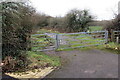
Llwybr Ceffyl yng Nghydweli / A bridleway in Kidwelly
Hen reilffordd sy bellach yn llwybr ceffyl.
The former railway is today a bridleway.
Image: © Alan Richards
Taken: 1 Feb 2021
0.12 miles
2
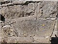
Ordnance Survey Cut Mark
This OS cut mark can be found on the wall of Glangwendraeth on Meinciau Road. It marks a point 19.864m above mean sea level.
Image: © Adrian Dust
Taken: 18 Apr 2023
0.13 miles
4
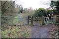
Llwybr Ceffyl yng Nghydweli / A bridleway in Kidwelly
Hen reilffordd sy bellach yn llwybr ceffyl.
The former railway is today a bridleway.
Image: © Alan Richards
Taken: 1 Feb 2021
0.22 miles
5
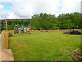
Playground at the northern end of Ger-y-Castell
Image: © Eirian Evans
Taken: 24 May 2022
0.23 miles
6
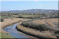
Gwendraeth Fach
Gwendraeth Fach winding through the valley at Kidwelly, here the river is viewed from Kidwelly Castle.
Image: © Philip Halling
Taken: 6 Apr 2013
0.24 miles