IMAGES TAKEN NEAR TO
Bro-Hedydd, KIDWELLY, SA17 4SQ
Introduction
This page details the photographs taken nearby to Bro-Hedydd, SA17 4SQ by members of the Geograph project.
The Geograph project started in 2005 with the aim of publishing, organising and preserving representative images for every square kilometre of Great Britain, Ireland and the Isle of Man.

There are currently over 7.5m images from over14,400 individuals and you can help contribute to the project by visiting https://www.geograph.org.uk
Image Map
Images are licensed for reuse under creativecommons.org/licenses/by-sa/2.0
Notes
- Clicking on the map will re-center to the selected point.
- The higher the marker number, the further away the image location is from the centre of the postcode.
Image Listing (7 Images Found)
Images are licensed for reuse under creativecommons.org/licenses/by-sa/2.0
Image
Details
Distance
1

Pedair Heol
Sign at the entrance to the village of Four Roads.
Image: © Alan Hughes
Taken: 5 May 2021
0.03 miles
2
Four roads at Four Roads
The crossroads which presumably give the village its name.
Image: © David Medcalf
Taken: 2 Oct 2007
0.08 miles
3

At the cross roads, Four Roads, Llangyndeyrn
Image: © Humphrey Bolton
Taken: 26 Oct 2016
0.09 miles

5
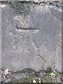
Ordnance Survey Cut Mark
This OS cut mark can be found on the wall to the west of the Bus Shelter. It marks a point 126.13m above mean sea level.
Image: © Adrian Dust
Taken: 4 Jan 2015
0.10 miles
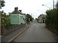
6

Pentre Pedair Heol / Four Roads Village
Heol fach yn cyrraedd pentre Pedair Heol.
A minor road entering the village of Four Roads.
Image: © Alan Richards
Taken: 20 Aug 2019
0.14 miles
7
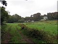
Llwybr Greenhall / Greenhall Path
Llwybr cyhoeddus yn mynd i gyfeiriad anhedd-dy o'r enw Greenhall.
A public footpath heading in the direction of a property known as Greenhall.
Image: © Alan Richards
Taken: 20 Aug 2019
0.20 miles