IMAGES TAKEN NEAR TO
Four Roads, KIDWELLY, SA17 4SL
Introduction
This page details the photographs taken nearby to SA17 4SL by members of the Geograph project.
The Geograph project started in 2005 with the aim of publishing, organising and preserving representative images for every square kilometre of Great Britain, Ireland and the Isle of Man.

There are currently over 7.5m images from over14,400 individuals and you can help contribute to the project by visiting https://www.geograph.org.uk
Image Map (Loading...)


Getting Data...Please wait
Leaflet Map data © OpenStreetMap
Images are licensed for reuse under creativecommons.org/licenses/by-sa/2.0
Notes
- Clicking on the map will re-center to the selected point.
- The higher the marker number, the further away the image location is from the centre of the postcode.
Image Listing (5 Images Found)
Images are licensed for reuse under creativecommons.org/licenses/by-sa/2.0
Image
Details
Distance
1
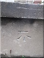
Ordnance Survey Cut Mark
This OS cut mark can be found on the east side of the road. It marks a point 158.17m above mean sea level.
Image: © Adrian Dust
Taken: 4 Jan 2015
0.01 miles
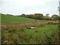
2
Llwybr Greenhall / Greenhall Path
Llwybr cyhoeddus yn mynd i gyfeiriad Ffarm Greenhall.
A public footpath heading towards Greenhall Farm.
Image: © Alan Richards
Taken: 20 Aug 2019
0.09 miles
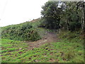
3
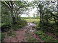
Llwybr Greenhall / Greenhall Path
Llwybr cyhoeddus yn mynd i gyfeiriad Blaen y Bryn a'r heol.
A public footpath heading towards Blaen y Bryn and the road.
Image: © Alan Richards
Taken: 20 Aug 2019
0.11 miles