
IMAGES TAKEN NEAR TO
Mynyddygarreg, KIDWELLY, SA17 4LS
Introduction
This page details the photographs taken nearby to SA17 4LS by members of the Geograph project.
The Geograph project started in 2005 with the aim of publishing, organising and preserving representative images for every square kilometre of Great Britain, Ireland and the Isle of Man.

There are currently over 7.5m images from over14,400 individuals and you can help contribute to the project by visiting https://www.geograph.org.uk
Image Map
Images are licensed for reuse under creativecommons.org/licenses/by-sa/2.0
Notes
- Clicking on the map will re-center to the selected point.
- The higher the marker number, the further away the image location is from the centre of the postcode.
Image Listing (2 Images Found)
Images are licensed for reuse under creativecommons.org/licenses/by-sa/2.0
Image
Details
Distance
1
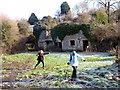
Ffarm Maes Gwenllian Farm
Cerddwyr yn mynd heibio i ffarm adfeiliedig o'r enw Maes Gwenllian. Enwyd yr amaethdy ar ol cadle gerllaw lle y lladdwyd Gwenllian, arweinydd y Cymry,gan y Normniaid yn 1137. Ar ol cael ei lladd fe dorrwyd ei phen hi bant. Disgrifiwyd hi yn 1188 gan Gerallt Cymro 'fel ryw ail Penthesilea, Brenhines Amazon'. Mae cofeb er cof amdani i'w gweld yng Nghastell Cydweli gerllaw.
Walkers passing the ruined Maes Gwenllian Farm, a name commemorating a battle which took place nearby in 1137 where Gwenllian, leader of the Welsh, was defeated and beheaded by the Normans. Writing in 1188 Geraldus Cambrensis (Gerald of Wales) described her as 'some second Penthesilea, Queen of the Amazon.' A memorial stone to her memory can be seen at nearby Kidwelly Castle.
Image: © Alan Richards
Taken: 30 Jan 2011
0.15 miles
2
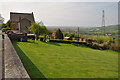
View across the Gwendraeth Fach valley toward Kidwelly
Image: © Mick Lobb
Taken: 18 Apr 2009
0.22 miles