IMAGES TAKEN NEAR TO
Bryn Seilo, KIDWELLY, SA17 4HR
Introduction
This page details the photographs taken nearby to Bryn Seilo, SA17 4HR by members of the Geograph project.
The Geograph project started in 2005 with the aim of publishing, organising and preserving representative images for every square kilometre of Great Britain, Ireland and the Isle of Man.

There are currently over 7.5m images from over14,400 individuals and you can help contribute to the project by visiting https://www.geograph.org.uk
Image Map (Loading...)


Getting Data...Please wait
Leaflet Map data © OpenStreetMap
Images are licensed for reuse under creativecommons.org/licenses/by-sa/2.0
Notes
- Clicking on the map will re-center to the selected point.
- The higher the marker number, the further away the image location is from the centre of the postcode.
Image Listing (5 Images Found)
Images are licensed for reuse under creativecommons.org/licenses/by-sa/2.0
Image
Details
Distance
2
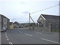
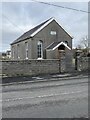
Maes -y-Wern, Carwe
Bethel Chapel on the right
Image: © John Lord
Taken: 17 Oct 2008
0.15 miles
4
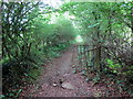
Llwybr Ynys Fawr / Ynys Fawr Footpath
Llwybr cyhoeddus yn mynd i gyfeiriad Ynys Fawr.
A public footpath heading in the direction of Ynys Fawr (trans. large river meadow).
Image: © Alan Richards
Taken: 4 Jun 2018
0.20 miles
5

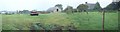
Ruin of Carway Social Club
There were plans to build houses on this site seven years ago but nothing seems to have been done.
Image: © Alan Hughes
Taken: 19 Feb 2023
0.23 miles