IMAGES TAKEN NEAR TO
Watkin Street, SWANSEA, SA1 6YE
Introduction
This page details the photographs taken nearby to Watkin Street, SA1 6YE by members of the Geograph project.
The Geograph project started in 2005 with the aim of publishing, organising and preserving representative images for every square kilometre of Great Britain, Ireland and the Isle of Man.

There are currently over 7.5m images from over14,400 individuals and you can help contribute to the project by visiting https://www.geograph.org.uk
Image Map
Images are licensed for reuse under creativecommons.org/licenses/by-sa/2.0
Notes
- Clicking on the map will re-center to the selected point.
- The higher the marker number, the further away the image location is from the centre of the postcode.
Image Listing (211 Images Found)
Images are licensed for reuse under creativecommons.org/licenses/by-sa/2.0
Image
Details
Distance
1
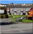
Jones Terrace flats, Swansea
Four-storey flats building viewed from New Orchard Street. The City Temple http://www.geograph.org.uk/photo/3669613 is on the right.
Image: © Jaggery
Taken: 16 Mar 2018
0.06 miles
2
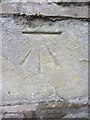
Ordnance Survey Cut Mark
This OS cut mark can be found on the wall of No66 North Hill Road. It marks a point 74.892m above mean sea level.
Image: © Adrian Dust
Taken: 23 Oct 2013
0.08 miles
3
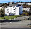
Graig Place flats, Swansea
Four-storey block of flats viewed from New Orchard Street.
Image: © Jaggery
Taken: 16 Mar 2018
0.08 miles
4

The City Temple, Swansea
Opened here in New Orchard Street in April 1975, the City Temple is the home of Swansea Elim Church.
Image: © Jaggery
Taken: 25 Sep 2013
0.09 miles
5
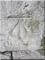
Ordnance Survey Rivet
This OS rivet can be found on the low wall in front of the corner shop, No1 Berwick Terrace. It marks a point 82.543m above mean sea level.
Image: © Adrian Dust
Taken: 23 Oct 2013
0.11 miles
6
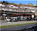
Unnamed premises, Dyfatty Street, Swansea
Viewed across the A4118 Dyfatty Street in March 2018. This looks like a former filling station.
Image: © Jaggery
Taken: 16 Mar 2018
0.11 miles
7
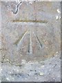
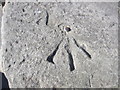
Ordnance Survey Cut Mark
This OS cut mark can be found on the wall to the SE of Fullers Row. It marks a point 39.392m above mean sea level.
Image: © Adrian Dust
Taken: 23 Oct 2013
0.11 miles
8
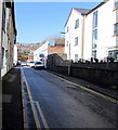
West along Tontine Street Swansea
From High Street along Tontine Street towards the A4118 Dyfatty Street.
Image: © Jaggery
Taken: 16 Mar 2018
0.11 miles
9
Ordnance Survey Cut Mark
This OS cut mark can be found on the wall to the NW of North Hill Road. It marks a point 62.140m above mean sea level.
Image: © Adrian Dust
Taken: 23 Oct 2013
0.12 miles
10
LDS Motor Factors premises and van, Swansea
At the western end of Ebenezer Street, on the corner of the A4118 New Orchard Street.
Motor factors sell car parts and accessories.
Image: © Jaggery
Taken: 16 Mar 2018
0.12 miles