1
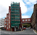
Clifton Hill, Swansea
Viewed across Alexandra Road from the corner of Pleasant Street. Clifton Hill is one of the steepest surfaced roads in the UK. I don't know its gradient, but at about 150 metres long, it is a stern test for a walker (or cyclist). I walked about halfway up then decided that going back down was the correct choice!
Image: © Jaggery
Taken: 6 Dec 2013
0.03 miles
2
Ordnance Survey Cut Mark
This OS cut mark can be found on the wall of No11 Clifton Hill. It marks a point 48.378m above mean sea level.
Image: © Adrian Dust
Taken: 23 Oct 2013
0.03 miles
3
Ordnance Survey Cut Mark
This OS cut mark can be found at the top of the steps on Fullers Row. It marks a point 49.615m above mean sea level.
Image: © Adrian Dust
Taken: 2 Nov 2020
0.05 miles
4
Main entrance to the University of Wales Trinity Saint David, Swansea
From the street named Mount Pleasant. Formerly part of Swansea Metropolitan University, this campus has been part of the University of Wales Trinity Saint David since a merger in the summer of 2013.
Image: © Jaggery
Taken: 27 Apr 2014
0.06 miles
5
Steps up to Mount Pleasant Campus, Swansea
From the street named Mount Pleasant. Formerly part of Swansea Metropolitan University, the campus has been part of the University of Wales Trinity Saint David since a merger in the summer of 2013.
Image: © Jaggery
Taken: 27 Apr 2014
0.06 miles
6
Ordnance Survey Cut Mark
This OS cut mark can be found on a wall to the NE of Mount Pleasant. It marks a point 40.752m above mean sea level.
Image: © Adrian Dust
Taken: 23 Aug 2013
0.06 miles
7
Ordnance Survey Cut Mark
This OS cut mark can be found on a wall to the NE of Mount Pleasant. It marks a point 45.513m above mean sea level.
Image: © Adrian Dust
Taken: 23 Aug 2013
0.07 miles
8
Ordnance Survey Rivet
This OS rivet can be found on a wall to the east of Bryn Syfi Street. It marks a point 54.358m above mean sea level.
Image: © Adrian Dust
Taken: 23 Oct 2013
0.07 miles
9
White railings on a steep gradient, Clifton Hill, Swansea
Clifton Hill is one of the steepest roads in Swansea,
and at about 150 metres long is a stern test for most walkers and cyclists.
Image: © Jaggery
Taken: 6 Dec 2013
0.08 miles
10
University buildings, Mount Pleasant, Swansea
Part of the University of Wales Trinity Saint David, Swansea campus.
Mount Pleasant is the street on the left side of the junction. Bryn Syfi Terrace is on the right.
Image: © Jaggery
Taken: 27 Apr 2014
0.08 miles


