IMAGES TAKEN NEAR TO
Nicander Parade, SWANSEA, SA1 6TX
Introduction
This page details the photographs taken nearby to Nicander Parade, SA1 6TX by members of the Geograph project.
The Geograph project started in 2005 with the aim of publishing, organising and preserving representative images for every square kilometre of Great Britain, Ireland and the Isle of Man.

There are currently over 7.5m images from over14,400 individuals and you can help contribute to the project by visiting https://www.geograph.org.uk
Image Map
Images are licensed for reuse under creativecommons.org/licenses/by-sa/2.0
Notes
- Clicking on the map will re-center to the selected point.
- The higher the marker number, the further away the image location is from the centre of the postcode.
Image Listing (65 Images Found)
Images are licensed for reuse under creativecommons.org/licenses/by-sa/2.0
Image
Details
Distance
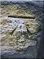
1
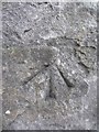
Ordnance Survey Cut Mark
This OS cut mark can be found on the wall of No26 Pen-Y-Graig Road. It marks a point 93.540m above mean sea level.
Image: © Adrian Dust
Taken: 31 Oct 2013
0.07 miles
2

Pen-y-Graig Road, Swansea
Pen-y-Graig Road on the right climbs away from Terrace Road.
Image: © Jaggery
Taken: 27 Apr 2014
0.07 miles
3

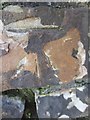
Hewson Street houses, Swansea
Viewed from Terrace Road.
Image: © Jaggery
Taken: 27 Apr 2014
0.08 miles
4
NEW
Benchmark 1 Islwyn Road Townhill
An Ordnance Cut Mark can be found on the boundary wall of 1 Islwyn Road, Townhill, Swansea. It marks a height of 141.327m above mean sea level.
Image: © John Jenkins
Taken: 12 Mar 2025
0.09 miles
5
Ordnance Survey Cut Mark
This OS cut mark can be found on the wall at the junction of Islwyn Road & Llewelyn Circle. It marks a point 141.327m above mean sea level.
Image: © Adrian Dust
Taken: 22 Nov 2013
0.09 miles
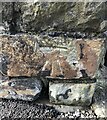
6
Ordnance Survey Cut Mark
This OS cut mark can be found on the rear wall of No3 Fairfield Terrace which is on Pen-Y-Graig Road. It marks a point 110.274m above mean sea level.
Image: © Adrian Dust
Taken: 31 Oct 2013
0.09 miles
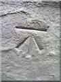
7
Ordnance Survey Cut Mark
This OS cut mark can be found on the school wall on Terrace Road. It marks a point 84.542m above mean sea level.
Image: © Adrian Dust
Taken: 31 Oct 2013
0.09 miles
8

Up Hewson Street Swansea
Hewson Street climbs steeply away from Terrace Road.
Image: © Jaggery
Taken: 27 Apr 2014
0.09 miles
9
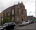
Terrace Road church, Swansea
The Presbyterian Church of Wales church was built as Terrace Road English (language) Calvinistic Methodist Chapel in 1893.
Image: © Jaggery
Taken: 27 Apr 2014
0.09 miles
10
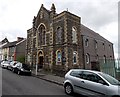
Terrace Road church, Swansea
The Presbyterian Church of Wales church was built as Terrace Road
English (language) Calvinistic Methodist Chapel in 1893.
Image: © Jaggery
Taken: 27 Apr 2014
0.09 miles