IMAGES TAKEN NEAR TO
Clos Yr Allt, SWANSEA, SA1 6RD
Introduction
This page details the photographs taken nearby to Clos Yr Allt, SA1 6RD by members of the Geograph project.
The Geograph project started in 2005 with the aim of publishing, organising and preserving representative images for every square kilometre of Great Britain, Ireland and the Isle of Man.

There are currently over 7.5m images from over14,400 individuals and you can help contribute to the project by visiting https://www.geograph.org.uk
Image Map (Loading...)


Getting Data...Please wait
Leaflet Map data © OpenStreetMap
Images are licensed for reuse under creativecommons.org/licenses/by-sa/2.0
Notes
- Clicking on the map will re-center to the selected point.
- The higher the marker number, the further away the image location is from the centre of the postcode.
Image Listing (5 Images Found)
Images are licensed for reuse under creativecommons.org/licenses/by-sa/2.0
Image
Details
Distance
1
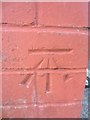
Ordnance Survey Cut Mark
This OS cut mark can be found on No32 Heol-Y-Gors. It marks a point 99.420m above mean sea level.
Image: © Adrian Dust
Taken: 12 Mar 2014
0.15 miles
2
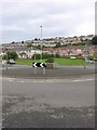
Roundabout on Gors Avenue
Facing SE. The church or chapel marked as being at the NW of this roundabout on the map has recently been demolished.
Image: © HelenK
Taken: 29 Sep 2007
0.17 miles
3
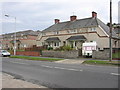
Aestivating housebling
Awaiting the festive season.
Image: © HelenK
Taken: 29 Sep 2007
0.22 miles
4

Western portal of Cockett railway tunnel, Swansea
Viewed from the A4216 Station Road in Fforestfach along the West Wales Line. The tunnel is 789 yards (721m) long. This used to be the site of Cockett railway station, where passenger services ceased in 1964.
Image: © Jaggery
Taken: 25 Sep 2013
0.24 miles
5
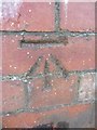
Ordnance Survey Cut Mark
This OS cut mark can be found at the junction of Geirol Road & Elphin Road. It marks a point 117.214m above mean sea level.
Image: © Adrian Dust
Taken: 12 Mar 2014
0.25 miles