IMAGES TAKEN NEAR TO
Townhill Road, SWANSEA, SA1 6QB
Introduction
This page details the photographs taken nearby to Townhill Road, SA1 6QB by members of the Geograph project.
The Geograph project started in 2005 with the aim of publishing, organising and preserving representative images for every square kilometre of Great Britain, Ireland and the Isle of Man.

There are currently over 7.5m images from over14,400 individuals and you can help contribute to the project by visiting https://www.geograph.org.uk
Image Map
Images are licensed for reuse under creativecommons.org/licenses/by-sa/2.0
Notes
- Clicking on the map will re-center to the selected point.
- The higher the marker number, the further away the image location is from the centre of the postcode.
Image Listing (12 Images Found)
Images are licensed for reuse under creativecommons.org/licenses/by-sa/2.0
Image
Details
Distance
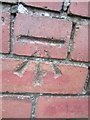
1
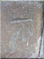
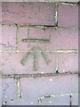
Ordnance Survey Cut Mark
This OS cut mark can be found on No150 Town Hill Road. It marks a point 171.901m above mean sea level.
Image: © Adrian Dust
Taken: 5 Dec 2013
0.09 miles
2
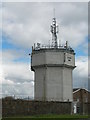
Swansea Water Tower
A mast on the roof was used by the Ordnance Survey as a 3rd Order Triangulation Point (Intersected Station SN80/T078).
Image: © Adrian Dust
Taken: 11 Apr 2011
0.11 miles
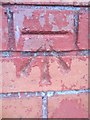
3
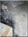
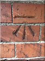
Ordnance Survey Cut Mark
This OS cut mark can be found at the wall junction to the north of Townhill Road. It marks a point 173.349m above mean sea level.
Image: © Adrian Dust
Taken: 20 Nov 2013
0.12 miles
4
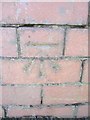
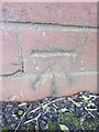
Ordnance Survey Cut Mark
This OS cut mark can be found at the junction of Elwy Crescent & Gwynedd Avenue. It marks a point 155.338m above mean sea level.
Image: © Adrian Dust
Taken: 12 Mar 2014
0.13 miles
5
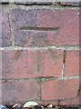
Ordnance Survey Cut Mark
This OS cut mark can be found on the wall of No55 Gwynedd Avenue. It marks a point 161.315m above mean sea level.
Image: © Adrian Dust
Taken: 30 Dec 2013
0.17 miles
6
Ordnance Survey Cut Mark
This OS cut mark can be found on the wall of No11 Elwy Crescent. It marks a point 161.440m above mean sea level.
Image: © Adrian Dust
Taken: 12 Mar 2014
0.17 miles
7
Ordnance Survey Cut Mark
This OS cut mark can be found on the wall of No61 Gwent Road. It marks a point 106.973m above mean sea level.
Image: © Adrian Dust
Taken: 12 Mar 2014
0.19 miles
8
Ordnance Survey Cut Mark
This OS cut mark can be found on the wall of No23 Gwent Road. It marks a point 115.449m above mean sea level.
Image: © Adrian Dust
Taken: 30 Dec 2013
0.20 miles
9
Ordnance Survey Cut Mark
This OS cut mark can be found on the wall of No123 Town Hill Road. It marks a point 161.581m above mean sea level.
Image: © Adrian Dust
Taken: 5 Dec 2013
0.22 miles
10
Ordnance Survey Cut Mark
This OS cut mark can be found on the wall of No109 Pant-Y-Celyn Road. It marks a point 146.603m above mean sea level.
Image: © Adrian Dust
Taken: 5 Dec 2013
0.23 miles