IMAGES TAKEN NEAR TO
Powys Avenue, SWANSEA, SA1 6PG
Introduction
This page details the photographs taken nearby to Powys Avenue, SA1 6PG by members of the Geograph project.
The Geograph project started in 2005 with the aim of publishing, organising and preserving representative images for every square kilometre of Great Britain, Ireland and the Isle of Man.

There are currently over 7.5m images from over14,400 individuals and you can help contribute to the project by visiting https://www.geograph.org.uk
Image Map (20 Images)


Getting Data...Please wait
Leaflet Map data © OpenStreetMap
Images are licensed for reuse under creativecommons.org/licenses/by-sa/2.0
Notes
- Clicking on the map will re-center to the selected point.
- The higher the marker number, the further away the image location is from the centre of the postcode.
Image Listing (20 Images Found)
Images are licensed for reuse under creativecommons.org/licenses/by-sa/2.0
Image
Details
Distance
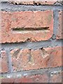
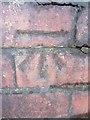
1
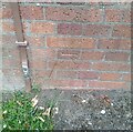
Ordnance Survey Cut Mark
This OS cut mark can be found on the NW angle of the school. It marks a point 166.966m above mean sea level.
Image: © Adrian Dust
Taken: 15 Jul 2024
0.06 miles
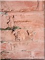
2
Ordnance Survey Cut Mark (Damaged)
This damaged OS cut mark can be found on No257 Townhill Road. It marks a point 152.906m above mean sea level.
Image: © Adrian Dust
Taken: 20 Nov 2013
0.15 miles
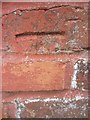
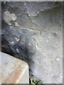
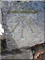
4
Ordnance Survey Cut Mark
This OS cut mark can be found on the wall below No1 Dyfed Avenue. It marks a point 137.995m above mean sea level.
Image: © Adrian Dust
Taken: 15 Jul 2024
0.15 miles
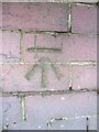
5
Ordnance Survey Cut Mark
This OS cut mark can be found on No55 Dyfed Avenue. It marks a point 166.948m above mean sea level.
Image: © Adrian Dust
Taken: 20 Nov 2013
0.17 miles
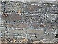
6
Ordnance Survey Cut Mark (Damaged)
This damaged OS cut mark can be found on No16 Pant-Y-Celyn Road. It marked a point 134.600m above mean sea level.
Image: © Adrian Dust
Taken: 20 Nov 2013
0.17 miles
7
Ordnance Survey Cut Mark
This OS cut mark can be found at the wall junction to the north of Townhill Road. It marks a point 173.349m above mean sea level.
Image: © Adrian Dust
Taken: 20 Nov 2013
0.18 miles
8
Ordnance Survey Cut Mark
This OS cut mark can be found on the wall of No55 Gwynedd Avenue. It marks a point 161.315m above mean sea level.
Image: © Adrian Dust
Taken: 30 Dec 2013
0.18 miles
9
Ordnance Survey Cut Mark
This OS cut mark can be found on the wall to the SW of Gwent Road. It marks a point 142.878m above mean sea level.
Image: © Adrian Dust
Taken: 30 Dec 2013
0.18 miles
10
Ordnance Survey Cut Mark
This OS cut mark can be found on the wall to the SE of Townhill Road. It marks a point 148.301m above mean sea level.
Image: © Adrian Dust
Taken: 30 Dec 2013
0.19 miles