IMAGES TAKEN NEAR TO
Peter Street, SWANSEA, SA1 6FH
Introduction
This page details the photographs taken nearby to Peter Street, SA1 6FH by members of the Geograph project.
The Geograph project started in 2005 with the aim of publishing, organising and preserving representative images for every square kilometre of Great Britain, Ireland and the Isle of Man.

There are currently over 7.5m images from over14,400 individuals and you can help contribute to the project by visiting https://www.geograph.org.uk
Image Map
Images are licensed for reuse under creativecommons.org/licenses/by-sa/2.0
Notes
- Clicking on the map will re-center to the selected point.
- The higher the marker number, the further away the image location is from the centre of the postcode.
Image Listing (45 Images Found)
Images are licensed for reuse under creativecommons.org/licenses/by-sa/2.0
Image
Details
Distance
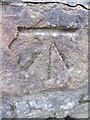
1
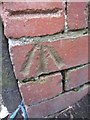
Ordnance Survey Cut Mark
This OS cut mark can be found on a brick pillar below No37 Peter Street. It marks a point 61.609m above mean sea level.
Image: © Adrian Dust
Taken: 11 Dec 2013
0.03 miles
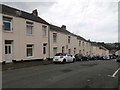
2
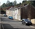
Peter Terrace Swansea
Viewed from the Carmarthen Road end.
Image: © Jaggery
Taken: 25 Sep 2013
0.04 miles
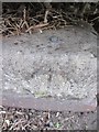
3
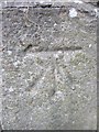
Ordnance Survey Cut Mark
This OS cut mark can be found on the wall of No1 Rockland Terrace. It marks a point 61.603m above mean sea level.
Image: © Adrian Dust
Taken: 11 Dec 2013
0.05 miles
4
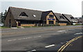
Pure Spice in Swansea
Viewed from Carmarthen Road looking towards the corner of Waun Wen Road.
The row of three shops contains Pure Spice Indian takeaway, Waun Wen Chippy and a Spar store.
Image: © Jaggery
Taken: 25 Sep 2013
0.05 miles
6
Ordnance Survey Cut Mark
This OS cut mark can be found on the wall of No33 Waun Wen Road. It marks a point 77.346m above mean sea level.
Image: © Adrian Dust
Taken: 11 Dec 2013
0.11 miles
7
Ordnance Survey Rivet
This OS rivet can be found on the wall of No399 Townhill Road. It marks a point 102.166m above mean sea level.
Image: © Adrian Dust
Taken: 11 Dec 2013
0.11 miles
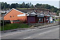
8
Cwmfelin Medical Centre Swansea
Viewed across Carmarthen Road. Cwmfelin Pharmacy http://www.geograph.org.uk/photo/3670740 is on the right.
Image: © Jaggery
Taken: 25 Sep 2013
0.11 miles
9
Ordnance Survey Cut Mark
This OS cut mark can be found below the road sign for Mayhill Road. It marks a point 97.003m above mean sea level.
Image: © Adrian Dust
Taken: 11 Dec 2013
0.12 miles