IMAGES TAKEN NEAR TO
Cromwell Street, SWANSEA, SA1 6EY
Introduction
This page details the photographs taken nearby to Cromwell Street, SA1 6EY by members of the Geograph project.
The Geograph project started in 2005 with the aim of publishing, organising and preserving representative images for every square kilometre of Great Britain, Ireland and the Isle of Man.

There are currently over 7.5m images from over14,400 individuals and you can help contribute to the project by visiting https://www.geograph.org.uk
Image Map
Images are licensed for reuse under creativecommons.org/licenses/by-sa/2.0
Notes
- Clicking on the map will re-center to the selected point.
- The higher the marker number, the further away the image location is from the centre of the postcode.
Image Listing (99 Images Found)
Images are licensed for reuse under creativecommons.org/licenses/by-sa/2.0
Image
Details
Distance
1
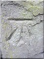
Ordnance Survey Cut Mark
This OS cut mark can be found on the wall of No1 Chaddesley Villas. It marks a point 55.065m above mean sea level.
Image: © Adrian Dust
Taken: 31 Oct 2013
0.03 miles
2
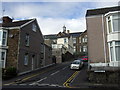
Rhondda Street, Mount Pleasant
Looking up Primrose Street towards Norfolk Street. The cupola marks Terrace Road Primary School.
Image: © Natasha Ceridwen de Chroustchoff
Taken: 21 Oct 2009
0.07 miles
3

Norfolk Street houses from Terrace Road, Swansea
Over perimeter railings of Terrace Road Primary School http://www.geograph.org.uk/photo/4046055 with a distant view of Swansea Bay.
Image: © Jaggery
Taken: 27 Apr 2014
0.07 miles
4
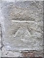
Ordnance Survey Cut Mark
This OS cut mark can be found on a garage on Heathfield. It marks a point 42.303m above mean sea level.
Image: © Adrian Dust
Taken: 31 Oct 2013
0.07 miles
5
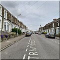
Rhondda Street
Just off the very steep Constitution Hill in Mount Pleasant.
Image: © Z Pryce
Taken: 7 Jun 2021
0.08 miles
6
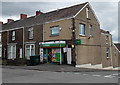
Norfolk Street Londis in Swansea
Convenience store at 49 Norfolk Street on the corner of Harcourt Street.
Image: © Jaggery
Taken: 27 Apr 2014
0.08 miles
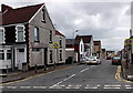
7

West along Norfolk Street, Swansea
From the corner of Harcourt Street.
Image: © Jaggery
Taken: 27 Apr 2014
0.08 miles
8
Harcourt Street, Swansea
Looking towards Norfolk Street from Terrace Road.
Image: © Jaggery
Taken: 27 Apr 2014
0.09 miles
9
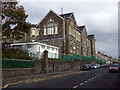
Terrace Road Primary School in Norfolk Street
Impressive Victorian school opened in 1888 to serve the growing population of this once-rural hillside. The school originally faced Terrace Road, above, but as numbers swelled it was extended downwards to provide more classrooms at a lower level here in Norfolk Street, with the result that the building has four storeys.
Image: © Natasha Ceridwen de Chroustchoff
Taken: 21 Oct 2009
0.09 miles
10
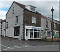
Norfolk Bakery, Swansea
On the NE corner of Norfolk Street and Harcourt Street.
Image: © Jaggery
Taken: 27 Apr 2014
0.09 miles