IMAGES TAKEN NEAR TO
Stanley Terrace, SWANSEA, SA1 6EW
Introduction
This page details the photographs taken nearby to Stanley Terrace, SA1 6EW by members of the Geograph project.
The Geograph project started in 2005 with the aim of publishing, organising and preserving representative images for every square kilometre of Great Britain, Ireland and the Isle of Man.

There are currently over 7.5m images from over14,400 individuals and you can help contribute to the project by visiting https://www.geograph.org.uk
Image Map
Images are licensed for reuse under creativecommons.org/licenses/by-sa/2.0
Notes
- Clicking on the map will re-center to the selected point.
- The higher the marker number, the further away the image location is from the centre of the postcode.
Image Listing (97 Images Found)
Images are licensed for reuse under creativecommons.org/licenses/by-sa/2.0
Image
Details
Distance
1
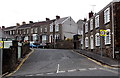
Stanley Terrace, Swansea
This is the northern end of Stanley Terrace, viewed across Mount Pleasant.
Image: © Jaggery
Taken: 27 Apr 2014
0.03 miles
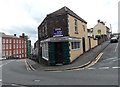
2
Tasty Cantonese takeaway in Swansea
On the corner of Norfolk Street and Stanley Place.
Image: © Jaggery
Taken: 27 Apr 2014
0.03 miles
3

East along Norfolk Street, Swansea
From Harcourt Street looking towards Stanley Place. Norfolk Bakery http://www.geograph.org.uk/photo/4002763 is on the left.
Image: © Jaggery
Taken: 27 Apr 2014
0.04 miles
4
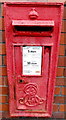
King Edward VII postbox, Mount Pleasant, Swansea
In the wall on the left side of the junction here. http://www.geograph.org.uk/photo/4002595
Image: © Jaggery
Taken: 27 Apr 2014
0.04 miles
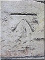
5
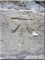
Ordnance Survey Cut Mark
This OS cut mark can be found on a wall to the NE of Mount Pleasant. It marks a point 45.513m above mean sea level.
Image: © Adrian Dust
Taken: 23 Aug 2013
0.04 miles
6
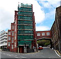
University buildings, Mount Pleasant, Swansea
Part of the University of Wales Trinity Saint David, Swansea campus.
Mount Pleasant is the street on the left side of the junction. Bryn Syfi Terrace is on the right.
Image: © Jaggery
Taken: 27 Apr 2014
0.05 miles
7
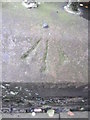
Ordnance Survey Rivet
This OS rivet can be found on a wall to the east of Bryn Syfi Street. It marks a point 54.358m above mean sea level.
Image: © Adrian Dust
Taken: 23 Oct 2013
0.05 miles
8
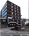
Main entrance to the University of Wales Trinity Saint David, Swansea
From the street named Mount Pleasant. Formerly part of Swansea Metropolitan University, this campus has been part of the University of Wales Trinity Saint David since a merger in the summer of 2013.
Image: © Jaggery
Taken: 27 Apr 2014
0.06 miles
9
Ordnance Survey Cut Mark
This OS cut mark can be found on a wall to the NE of Mount Pleasant. It marks a point 40.752m above mean sea level.
Image: © Adrian Dust
Taken: 23 Aug 2013
0.06 miles
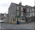
10
Cosy Cafe, Swansea
In late April 2014 there was a Freehold For Sale board on the wall
of Cosy Cafe, 73 Mount Pleasant, on the corner of Stanley Place (on the right).
Image: © Jaggery
Taken: 27 Apr 2014
0.07 miles