IMAGES TAKEN NEAR TO
St. James Crescent, SWANSEA, SA1 6DL
Introduction
This page details the photographs taken nearby to St. James Crescent, SA1 6DL by members of the Geograph project.
The Geograph project started in 2005 with the aim of publishing, organising and preserving representative images for every square kilometre of Great Britain, Ireland and the Isle of Man.

There are currently over 7.5m images from over14,400 individuals and you can help contribute to the project by visiting https://www.geograph.org.uk
Image Map (Loading...)


Getting Data...Please wait
Leaflet Map data © OpenStreetMap
Images are licensed for reuse under creativecommons.org/licenses/by-sa/2.0
Notes
- Clicking on the map will re-center to the selected point.
- The higher the marker number, the further away the image location is from the centre of the postcode.
Image Listing (100 Images Found)
Images are licensed for reuse under creativecommons.org/licenses/by-sa/2.0
Image
Details
Distance
1
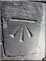
Ordnance Survey Cut Mark
This OS cut mark can be found at the junction of St James Crescent & St James Gardens. It marks a point 31.684m above mean sea level.
Image: © Adrian Dust
Taken: 14 Nov 2013
0.02 miles
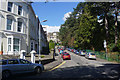
2
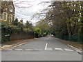
St James Gardens, Swansea
The road named St James Gardens descends from Ffynone Road past the eastern edge of the small park named St James Gardens.
Image: © Jaggery
Taken: 27 Apr 2014
0.02 miles
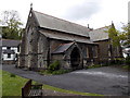
3
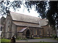
St James' Church Uplands
St James' Church, Uplands taken from the bus stop on Walters Road in March.
Image: © Jenny Thomas
Taken: 16 Mar 2012
0.03 miles
4
Swansea: St James?s Church, Uplands
Looking east-north-east
Image: © Martin Bodman
Taken: 10 Jun 2006
0.03 miles
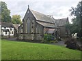
5
St James Church, Swansea
Anglican (Church in Wales) church on the north side of the A4118 Walter Road.
Image: © Jaggery
Taken: 27 Apr 2014
0.03 miles
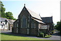
6
St.James' Church
Parish church of St.James in Uplands, Swansea.
Image: © Alan Hughes
Taken: 14 Aug 2017
0.03 miles
7
SE corner of St James Crescent, Swansea
Viewed from the A4118 Walter Road end.
Image: © Jaggery
Taken: 27 Apr 2014
0.04 miles
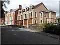
8
St James Court, Swansea
Housing at the edge of the churchyard of St James Church http://www.geograph.org.uk/photo/3955589 on the right.
Image: © Jaggery
Taken: 27 Apr 2014
0.04 miles
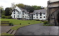
9
St James Gardens
St James Gardens comprises a broad strip of gardens with a road on each side leading up the hillside.
Image: © Bill Boaden
Taken: 5 Apr 2016
0.05 miles
10

No entry to the northern end of Bullins Lane, Swansea
Viewed across Ffynone Road.
Image: © Jaggery
Taken: 27 Apr 2014
0.05 miles