IMAGES TAKEN NEAR TO
Dwynant, BURRY PORT, SA16 0YQ
Introduction
This page details the photographs taken nearby to Dwynant, SA16 0YQ by members of the Geograph project.
The Geograph project started in 2005 with the aim of publishing, organising and preserving representative images for every square kilometre of Great Britain, Ireland and the Isle of Man.

There are currently over 7.5m images from over14,400 individuals and you can help contribute to the project by visiting https://www.geograph.org.uk
Image Map (Loading...)


Getting Data...Please wait
Leaflet Map data © OpenStreetMap
Images are licensed for reuse under creativecommons.org/licenses/by-sa/2.0
Notes
- Clicking on the map will re-center to the selected point.
- The higher the marker number, the further away the image location is from the centre of the postcode.
Image Listing (36 Images Found)
Images are licensed for reuse under creativecommons.org/licenses/by-sa/2.0
Image
Details
Distance
1
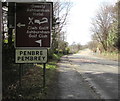
Penbre/Pembrey boundary sign, Gwscwm Road
The bilingual sign alongside the A484 Gwscwm Road shows that Pembrey is Penbre in Welsh.
A Welcome to Burry Port sign https://www.geograph.org.uk/photo/5711987 is on the back of this sign.
Image: © Jaggery
Taken: 16 Mar 2018
0.02 miles
2
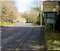
Welcome to Burry Port - Please drive carefully
The bilingual sign alongside the A484 Gwscwm Road shows that Burry Port is Porth Tywyn in Welsh.
The Pembrey boundary sign https://www.geograph.org.uk/photo/5711994 is on the back of this sign.
Image: © Jaggery
Taken: 16 Mar 2018
0.02 miles
4
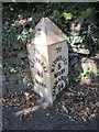
Grade II listed milepost, Gwscwm Road, Burry Port
On the northwest side of the A484 Gwscwm Road near the Pembrey boundary. https://www.geograph.org.uk/photo/5425523 to a closer view.
Cadw records that this late 19th century milepost is one of a series on the Llanelli to Kidwelly road cast by Glanmor Foundry Company of Llanelli, and shown on the 1880 Ordnance Survey. Grade II listed for its special interest as one of a series of well-preserved mileposts on the A484.
Image: © Jaggery
Taken: 16 Mar 2018
0.03 miles
5
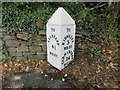
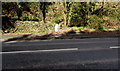
Old Milepost by the A484, Furnace, Burry Port
Cast-iron post on the A484, in the community of Cefn Sidan, Carmarthenshire; Furnace, on Gwscwm Road, North-west side of road. Erected by the Carmarthenshire Turnpike Trust, C19.
Inscription reads:-
: TO / LLANELLY / 4½ / MILES : : TO / KIDWELLY / 5 MILES / CARMARTHEN 14 / MILES :
Grade II listed by CADW.
Reference Number: 820707 https://cadwpublic-api.azurewebsites.net/reports/listedbuilding/FullReport?lang=&id=82070
Milestone Society National ID: CAM_LEKW04.
Image: © Milestone Society
Taken: 28 May 2017
0.03 miles
6
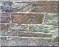
Ordnance Survey Cut Mark
This OS cut mark can be found on the wall of No77 Gwscwm Road. It marks a point 20.842m above mean sea level.
Image: © Adrian Dust
Taken: 8 Jan 2022
0.04 miles
7
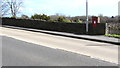
Gwscwm Road postbox, Pembrey
In the end of a long stone wall alongside the A484 Gwscwm Road on the approach to Burry Port.
Image: © Jaggery
Taken: 16 Mar 2018
0.06 miles
8
Gwscwm Road bus stop and shelter, Pembrey
Opposite the Furnace Road junction near the western boundary of Burry Port.
Image: © Jaggery
Taken: 16 Mar 2018
0.06 miles
9
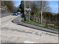
Corner of Gwscwm Road and Furnace Road, Pembrey
The bilingual sign shows that Furnace Road is Heol Ffwrnes in Welsh.
Image: © Jaggery
Taken: 16 Mar 2018
0.07 miles
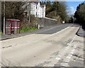
10
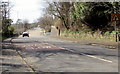
Gwscwm Road towards the centre of Pembrey
Here named Gwscwm Road, the A484 from Burry Port heads towards the centre of Pembrey.
The staggered crossroads warning sign is on the approach to the Furnace Road junction and the Y Cwm junction.
Image: © Jaggery
Taken: 16 Mar 2018
0.07 miles