IMAGES TAKEN NEAR TO
Heol Panteg, BURRY PORT, SA16 0YH
Introduction
This page details the photographs taken nearby to Heol Panteg, SA16 0YH by members of the Geograph project.
The Geograph project started in 2005 with the aim of publishing, organising and preserving representative images for every square kilometre of Great Britain, Ireland and the Isle of Man.

There are currently over 7.5m images from over14,400 individuals and you can help contribute to the project by visiting https://www.geograph.org.uk
Image Map (Loading...)


Getting Data...Please wait
Leaflet Map data © OpenStreetMap
Images are licensed for reuse under creativecommons.org/licenses/by-sa/2.0
Notes
- Clicking on the map will re-center to the selected point.
- The higher the marker number, the further away the image location is from the centre of the postcode.
Image Listing (57 Images Found)
Images are licensed for reuse under creativecommons.org/licenses/by-sa/2.0
Image
Details
Distance
1
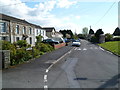
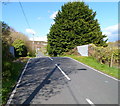
Heol Panteg, Pembrey
Viewed from the corner of Orchard Close.
Image: © Jaggery
Taken: 15 Apr 2012
0.02 miles
2
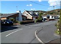
Heol Panteg houses, Pembrey
Viewed from the corner of Heol Waun-Wen.
Image: © Jaggery
Taken: 15 Apr 2012
0.02 miles
3
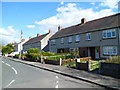
Heol Waun-Wen houses, Pembrey
Looking eastwards from the corner of Heol Panteg.
Image: © Jaggery
Taken: 15 Apr 2012
0.04 miles
4
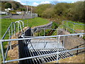
Platform over a stream near a culvert in Orchard Close, Pembrey
The stream flows under the platform and into a culvert beneath Orchard Close and Heol Panteg.
Image: © Jaggery
Taken: 15 Apr 2012
0.05 miles
5
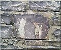
Ordnance Survey Cut Mark
This OS cut mark can be found on the wall of No1 Furnace Road. It marks a point 10.571m above mean sea level.
Image: © Adrian Dust
Taken: 8 Jan 2022
0.07 miles
6
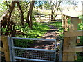
Track on the north side of Burry Road, Pembrey
The track heads away from Burry Road near the corner of Heol Waun-Wen.
A nearby sign http://www.geograph.org.uk/photo/3618294 shows the penalties for fly tipping or littering here.
Image: © Jaggery
Taken: 15 Apr 2012
0.07 miles
7
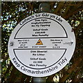
Keep Carmarthenshire Tidy, Pembrey
Located near this track. http://www.geograph.org.uk/photo/3618293 At the April 2012 date of this view, the maximum penalty for fly tipping was £50,000 and for littering £2,500. The area is covered by CCTV surveillance.
Image: © Jaggery
Taken: 15 Apr 2012
0.07 miles
8
Track heads ESE away from Furnace Road, Pembrey
Viewed from this http://www.geograph.org.uk/photo/3618331 humpback bridge.
http://www.geograph.org.uk/photo/3618339 to a view of the track on the opposite side of the bridge.
Image: © Jaggery
Taken: 15 Apr 2012
0.07 miles
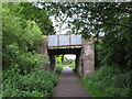
9
Humpback bridge, Furnace Road, Pembrey
The bridge crosses what looks like a disused water channel, now a track. http://www.geograph.org.uk/photo/3618339
Image: © Jaggery
Taken: 15 Apr 2012
0.08 miles
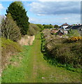
10
Former canal and railway route in Burry Port
Image: © Gareth James
Taken: 3 Jun 2021
0.08 miles