IMAGES TAKEN NEAR TO
Danlan Road, BURRY PORT, SA16 0UE
Introduction
This page details the photographs taken nearby to Danlan Road, SA16 0UE by members of the Geograph project.
The Geograph project started in 2005 with the aim of publishing, organising and preserving representative images for every square kilometre of Great Britain, Ireland and the Isle of Man.

There are currently over 7.5m images from over14,400 individuals and you can help contribute to the project by visiting https://www.geograph.org.uk
Image Map
Images are licensed for reuse under creativecommons.org/licenses/by-sa/2.0
Notes
- Clicking on the map will re-center to the selected point.
- The higher the marker number, the further away the image location is from the centre of the postcode.
Image Listing (73 Images Found)
Images are licensed for reuse under creativecommons.org/licenses/by-sa/2.0
Image
Details
Distance
1
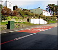
BT telecoms cabinet, Dan Lan Road, Pembrey
On the north side of the A484 Dan Lan Road near a Welsh/English ARAF/SLOW on the road surface.
Image: © Jaggery
Taken: 8 Mar 2018
0.04 miles
2
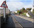
Warning sign - skid risk, Pembrey
Facing westbound traffic on the A484 Dan Lan Road.
Image: © Jaggery
Taken: 8 Mar 2018
0.04 miles
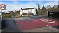
3
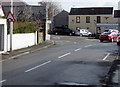
Junction of Dan Lan Road and Randell Square, Pembrey
On the right the B4311 Randell Square descends from the A484 Dan Lan Road.
The top of the tower of St Illtyd's Church https://www.geograph.org.uk/photo/5701330 is in the background.
Image: © Jaggery
Taken: 8 Mar 2018
0.04 miles
4
Direction and distance sign on a Pembrey corner
Located here https://www.geograph.org.uk/photo/5702596 on the corner of the A484 and Randell Square,
a mile and a quarter from Burry Port town centre and the harbour.
Image: © Jaggery
Taken: 8 Mar 2018
0.04 miles
5
End of the 20 zone at the northwest edge of Randell Square, Pembrey
The 20mph speed limit on the B4311 Randell Square increases to 30mph at the A484 junction.
Image: © Jaggery
Taken: 8 Mar 2018
0.05 miles
6
Directions sign alongside the A484 Dan Lan Road, Pembrey
Stay on the A484 for Llanelli or turn right ahead onto the B4311 for Burry Port (Porth Tywyn in Welsh).
Image: © Jaggery
Taken: 8 Mar 2018
0.05 miles
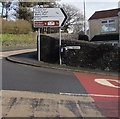
7
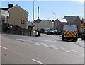
Junction of the A484 and B4311, Pembrey
The 30mph speed limit on the A484 drops to 20mph on the B4311 Randell Square on the approach to a school.
Image: © Jaggery
Taken: 8 Mar 2018
0.06 miles
8
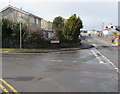
Corner of Danlan Park and Dan Lan Road, Pembrey
The A484 Dan Lan Road is on the right, the cul-de-sac Danlan Park https://www.geograph.org.uk/photo/5703851 on the left.
Image: © Jaggery
Taken: 8 Mar 2018
0.07 miles
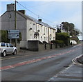
9
Warning sign - humpback bridge, Randell Square, Pembrey
The triangular sign is alongside the B4311 Randell Square. Pembrey Country Inn https://www.geograph.org.uk/photo/5701227 is in the background.
Image: © Jaggery
Taken: 8 Mar 2018
0.08 miles
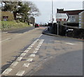
10
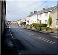
West along Dan Lan Road, Pembrey
Part of the A484.
Image: © Jaggery
Taken: 8 Mar 2018
0.08 miles