IMAGES TAKEN NEAR TO
Ashburnham Road, BURRY PORT, SA16 0TH
Introduction
This page details the photographs taken nearby to Ashburnham Road, SA16 0TH by members of the Geograph project.
The Geograph project started in 2005 with the aim of publishing, organising and preserving representative images for every square kilometre of Great Britain, Ireland and the Isle of Man.

There are currently over 7.5m images from over14,400 individuals and you can help contribute to the project by visiting https://www.geograph.org.uk
Image Map
Images are licensed for reuse under creativecommons.org/licenses/by-sa/2.0
Notes
- Clicking on the map will re-center to the selected point.
- The higher the marker number, the further away the image location is from the centre of the postcode.
Image Listing (55 Images Found)
Images are licensed for reuse under creativecommons.org/licenses/by-sa/2.0
Image
Details
Distance
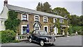
1
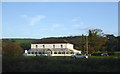
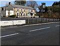
The Ashburnham Hotel, Burry Port
On Ashburnham Road.
Image: © JThomas
Taken: 16 Oct 2019
0.01 miles
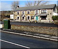
2
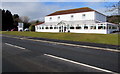
Ashburnham Hotel, Pembrey
Set back from the north side of the B4311 Ashburnham Road.
Image: © Jaggery
Taken: 8 Mar 2018
0.01 miles
3
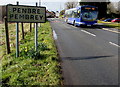
X11 bus for Llanelli leaves Pembrey
The bus on the B4311 Ashburnham Road is about to enter the town of Burry Port. https://www.geograph.org.uk/photo/5701357
The sign shows that Pembrey is Penbre in Welsh.
Image: © Jaggery
Taken: 8 Mar 2018
0.03 miles
4
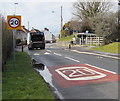
From 30 to 20 in Pembrey
The 30mph speed limit on the B4311 Ashburnham Road drops to
20mph on the approach to a school. Speed bumps are ahead.
Image: © Jaggery
Taken: 8 Mar 2018
0.04 miles
5
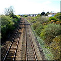
West Wales Line railway viewed from the B4311, Burry Port
Viewed from this http://www.geograph.org.uk/photo/3622286 road bridge looking west along the West Wales Line railway towards a footbridge 220 metres from the camera.
Image: © Jaggery
Taken: 15 Apr 2012
0.06 miles
6
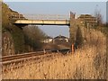
Footbridge over Railway
Footbridge over the West Wales railway line at Ashburnham golf course.
Image: © Alan Hughes
Taken: 17 Mar 2016
0.07 miles
7
Ship Aground Inn, Pembrey
Pub set back from the north side of the B4311 Ashburnham Road.
Image: © Jaggery
Taken: 8 Mar 2018
0.07 miles
8
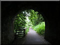
Former canal and railway route in Burry Port
Image: © Gareth James
Taken: 3 Jun 2021
0.08 miles
9
BT telecoms cabinet near the Ship Aground Inn, Pembrey
On the north side of the B4311 Ashburnham Road.
Image: © Jaggery
Taken: 8 Mar 2018
0.08 miles
10
Pembrey-The Ship Aground Inn
On Ashburnham Road.
Image: © Ian Rob
Taken: 28 Jun 2021
0.08 miles