IMAGES TAKEN NEAR TO
Llys Mair, BURRY PORT, SA16 0SZ
Introduction
This page details the photographs taken nearby to Llys Mair, SA16 0SZ by members of the Geograph project.
The Geograph project started in 2005 with the aim of publishing, organising and preserving representative images for every square kilometre of Great Britain, Ireland and the Isle of Man.

There are currently over 7.5m images from over14,400 individuals and you can help contribute to the project by visiting https://www.geograph.org.uk
Image Map
Images are licensed for reuse under creativecommons.org/licenses/by-sa/2.0
Notes
- Clicking on the map will re-center to the selected point.
- The higher the marker number, the further away the image location is from the centre of the postcode.
Image Listing (70 Images Found)
Images are licensed for reuse under creativecommons.org/licenses/by-sa/2.0
Image
Details
Distance
1
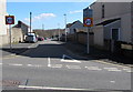
Bryn Avenue, Burry Port
From Church Road along Bryn Avenue towards St Mary's Rise.
Image: © Jaggery
Taken: 13 Mar 2018
0.04 miles
2
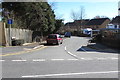
Llys Mair, Burry Port
Cul-de-sac viewed across Church Road.
Image: © Jaggery
Taken: 13 Mar 2018
0.05 miles
3
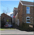
Dyfatty Terrace, Burry Port
On the east side of Church Road. The sign on the right shows that Dyfatty Terrace is Teras Dyfatty in Welsh.
Image: © Jaggery
Taken: 13 Mar 2018
0.06 miles
4
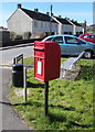
Queen Elizabeth II postbox on a Burry Port corner
Near a bench and litter bin on the corner of Church Road and Heol Dyfatty.
Image: © Jaggery
Taken: 13 Mar 2018
0.07 miles
5
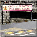
Cl?s y Pinwydd/Pinetree Close name sign, Burry Port
The Welsh/English sign is on the left here. https://www.geograph.org.uk/photo/5715403
Image: © Jaggery
Taken: 13 Mar 2018
0.08 miles
6
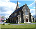
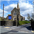
St Mary's Church, Burry Port
Located on the east side of Church Road. A landmark for miles around, the church was a gift to the town from the Elkington family of Birmingham who came to Burry Port in the mid 19th century to establish a copperworks industry near the harbour. The growing town needed a new church to serve both a rapidly-growing population in this part of the ancient parish of Pembrey, and also a non Welsh speaking workforce who had moved into the area. The church, built in the French gothic style, opened for worship on December 9th 1877. It remained a Chapel of Ease of the parish of Pembrey until it became the Parish Church of the newly created parish of Burry Port with Pwll in 1959
Image: © Jaggery
Taken: 15 Apr 2012
0.09 miles
8
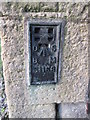
Ordnance Survey Flush Bracket (S1158)
This OS Flush Bracket can be found on the NE face of St Mary's Church. It marks a point 17.864m above mean sea level.
Image: © Adrian Dust
Taken: 29 Nov 2014
0.09 miles
9
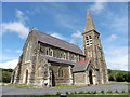
Entrance to St Mary's Church Burry Port
Viewed across Church Road. A landmark for miles around, the church was a gift to the town from the Elkington family of Birmingham who came to Burry Port in the mid 19th century to establish a copperworks industry near the harbour. The growing town needed a new church to serve both a rapidly-growing population in this part of the ancient parish of Pembrey, and also a non Welsh speaking workforce who had moved into the area. The church, built in the French gothic style, opened for worship on December 9th 1877. It remained a Chapel of Ease of the parish of Pembrey until it became the Parish Church of the newly created parish of Burry Port with Pwll in 1959.
Image: © Jaggery
Taken: 15 Apr 2012
0.09 miles
10
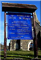
Information board for St Mary's Church, Burry Port
Facing Church Road near the entrance gate to this https://www.geograph.org.uk/photo/5827500 church, viewed in March 2018.
Image: © Jaggery
Taken: 13 Mar 2018
0.09 miles