IMAGES TAKEN NEAR TO
Y Rhodfa, BURRY PORT, SA16 0SP
Introduction
This page details the photographs taken nearby to Y Rhodfa, SA16 0SP by members of the Geograph project.
The Geograph project started in 2005 with the aim of publishing, organising and preserving representative images for every square kilometre of Great Britain, Ireland and the Isle of Man.

There are currently over 7.5m images from over14,400 individuals and you can help contribute to the project by visiting https://www.geograph.org.uk
Image Map
Images are licensed for reuse under creativecommons.org/licenses/by-sa/2.0
Notes
- Clicking on the map will re-center to the selected point.
- The higher the marker number, the further away the image location is from the centre of the postcode.
Image Listing (52 Images Found)
Images are licensed for reuse under creativecommons.org/licenses/by-sa/2.0
Image
Details
Distance
1
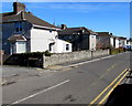
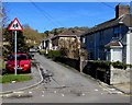
Houses on the north side of Tyle Teg, Burry Port
Viewed from the corner of Church Road. Ardwyn is on the left. https://www.geograph.org.uk/photo/5715137
Image: © Jaggery
Taken: 13 Mar 2018
0.04 miles
2
Bus stop and an old milepost, Burry Port
Located on the north side of the A484 Pwll Road.
The milepost http://www.geograph.org.uk/photo/3608732 shows 3½ miles to Llanelly (now spelt Llanelli), 6 to Kidwelly and 15 to Carmarthen.
Image: © Jaggery
Taken: 15 Apr 2012
0.05 miles
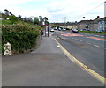
4
Western end of Tyle Teg, Burry Port
The 30mph speed limit on Church Road drops to 20mph along Tyle Teg.
Image: © Jaggery
Taken: 13 Mar 2018
0.06 miles
5
Ardwyn houses, Burry Port
Viewed across Tyle Teg. This part of Ardwyn is parallel with Church Road out of shot on the left.
Image: © Jaggery
Taken: 13 Mar 2018
0.06 miles
6

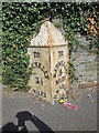
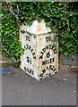
Old Milepost by the A484, Pwll Road, Cefn Sidan parish
Carmarthen pyramid by the A484, in parish of Cefn Sidan (Carmarthenshire District), Burry Port, on North side of Pwll Road.
Inscription reads:-
: TO / LLANELLY / 3½ MILES : : TO / KIDWELLY / 6 MILES / CARMARTHEN / 15 :
Grade II listed by Cadw.
Reference Number: 82068 https://cadwpublic-api.azurewebsites.net/reports/listedbuilding/FullReport?lang=&id=82068
To be surveyed
Milestone Society National ID: CAM_LEKW03
Image: © Milestone Society
Taken: Unknown
0.06 miles
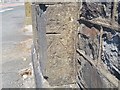
7
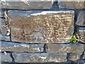
Ordnance Survey Cut Mark
This OS cut mark can be found on the wall north side of the road. It marks a point 21.842m above mean sea level.
Image: © Adrian Dust
Taken: 31 May 2020
0.06 miles
8
Old milepost, Pwll Road, Burry Port
Located here. http://www.geograph.org.uk/photo/3608725
Image: © Jaggery
Taken: 15 Apr 2012
0.06 miles
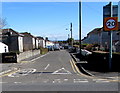
9
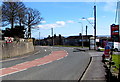
Bend in the A484, Burry Port
Ahead on the A484 for Llanelli via the village of Pwll.
Turn right for Church Road towards Burry Port town centre.
The edge of a Murco filling station https://www.geograph.org.uk/photo/5715121 is on the right.
Image: © Jaggery
Taken: 13 Mar 2018
0.06 miles
10
Ordnance Survey Cut Mark
This OS cut mark can be found on the gatepost north side of the road. It marks a point 72.23ft above mean sea level.
Image: © Adrian Dust
Taken: 31 May 2020
0.07 miles