IMAGES TAKEN NEAR TO
Pencoed Road, BURRY PORT, SA16 0PD
Introduction
This page details the photographs taken nearby to Pencoed Road, SA16 0PD by members of the Geograph project.
The Geograph project started in 2005 with the aim of publishing, organising and preserving representative images for every square kilometre of Great Britain, Ireland and the Isle of Man.

There are currently over 7.5m images from over14,400 individuals and you can help contribute to the project by visiting https://www.geograph.org.uk
Image Map
Images are licensed for reuse under creativecommons.org/licenses/by-sa/2.0
Notes
- Clicking on the map will re-center to the selected point.
- The higher the marker number, the further away the image location is from the centre of the postcode.
Image Listing (187 Images Found)
Images are licensed for reuse under creativecommons.org/licenses/by-sa/2.0
Image
Details
Distance
1
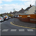
Heol Elizabeth, Burry Port
Viewed from Pencoed Road. Some maps show Heol Elisabeth, but the street name sign disagrees.
Image: © Jaggery
Taken: 15 Apr 2012
0.04 miles
2
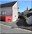
Cae Dolau, Burry Port
Dead-end road viewed across Pencoed Road.
Image: © Jaggery
Taken: 13 Mar 2018
0.05 miles
3
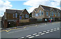
Burry Port Junior Community School
Viewed across Stepney Road, Burry Port.
Image: © Jaggery
Taken: 15 Apr 2012
0.05 miles
4
Old school
Formerly a school, now Carmarthenshire Secondary Teaching and Learning Centre.
Image: © Alan Hughes
Taken: 16 Oct 2019
0.05 miles
5
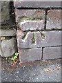
Ordnance Survey Cut Mark
This OS cut mark can be found at the wall junction of St Mary's Court. It marks a point 12.799m above mean sea level.
Image: © Adrian Dust
Taken: 29 Nov 2014
0.05 miles
6

Row of houses, Stepney Road, Burry Port
The parked cars are opposite the Mansel Street junction.
Image: © Jaggery
Taken: 16 Mar 2018
0.05 miles
7
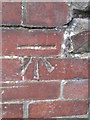
Ordnance Survey Cut Mark
This OS cut mark can be found on the wall of St Mary's Court. It marks a point 8.8758m above mean sea level.
Image: © Adrian Dust
Taken: 29 Nov 2014
0.06 miles
8
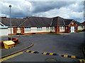
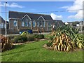
The Health Centre, Burry Port
Opened in 1998, the health centre is set back from the east side of Parc-y-minos Street near Memorial Square.
Image: © Jaggery
Taken: 15 Apr 2012
0.06 miles
9
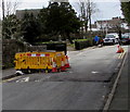
Yellow temporary barrier, Stepney Road, Burry Port
The barrier is above a hole in the road at the edge of a speed bump on March 16th 2018.
Image: © Jaggery
Taken: 16 Mar 2018
0.06 miles
10
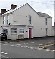
House on the corner of Stepney Road and Mansel Street, Burry Port
The house has the appearance of a converted former corner shop - a shop door
may once have been where the slightly recessed central ground floor window is now.
Image: © Jaggery
Taken: 16 Mar 2018
0.06 miles