IMAGES TAKEN NEAR TO
Glanmor Terrace, BURRY PORT, SA16 0LS
Introduction
This page details the photographs taken nearby to Glanmor Terrace, SA16 0LS by members of the Geograph project.
The Geograph project started in 2005 with the aim of publishing, organising and preserving representative images for every square kilometre of Great Britain, Ireland and the Isle of Man.

There are currently over 7.5m images from over14,400 individuals and you can help contribute to the project by visiting https://www.geograph.org.uk
Image Map
Images are licensed for reuse under creativecommons.org/licenses/by-sa/2.0
Notes
- Clicking on the map will re-center to the selected point.
- The higher the marker number, the further away the image location is from the centre of the postcode.
Image Listing (194 Images Found)
Images are licensed for reuse under creativecommons.org/licenses/by-sa/2.0
Image
Details
Distance
1
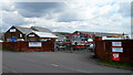
Gower Marine Services, Burry Port
Located on the corner of Ashburnham Road and an unnamed road from Burry Port Harbour.
Image: © Jaggery
Taken: 15 Apr 2012
0.02 miles
2
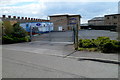
Hapus Dyrfa nursery, Burry Port
Hapus Dyrfa is privately-owned day nursery, located in Cambrian House, Glanmor Terrace.
Image: © Jaggery
Taken: 15 Apr 2012
0.03 miles
3
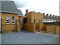
Leslie Griffiths Centre, Burry Port
Steps lead up to the recently-built Leslie Griffiths Centre, located at the back of the English Methodist Church. http://www.geograph.org.uk/photo/3603876 The Centre contains a modern meeting/conference room and adjacent kitchen facilities.
Image: © Jaggery
Taken: 15 Apr 2012
0.04 miles
4
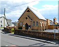
English Methodist Church, Burry Port
Viewed across Glanmor Terrace.
The inscription in the lozenge above the doorway is Wesleyan Chapel 1866.
Image: © Jaggery
Taken: 15 Apr 2012
0.05 miles
5
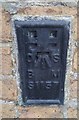
Ordnance Survey Flush Bracket (S1157)
This OS Flush Bracket can be found on the north face of the Methodist Church. It marks a point 23.995ft above mean sea level.
Image: © Adrian Dust
Taken: 31 Oct 2017
0.05 miles
6
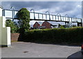
Railway footbridge, Burry Port
Viewed from Station Road. The footbridge over the West Wales Line railway leads to
Ashburnham Road. Pembrey and Burry Port railway station is nearby.
Image: © Jaggery
Taken: 15 Apr 2012
0.09 miles
7
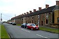
Silver Terrace, Burry Port
Viewed from the corner of Glanmor Terrace.
Image: © Jaggery
Taken: 15 Apr 2012
0.09 miles
8
Towards Pembrey and Burry Port railway station
A view west along the West Wales Line from this http://www.geograph.org.uk/photo/3604460 level crossing. A signalbox http://www.geograph.org.uk/photo/3604445 is on the right.
Image: © Jaggery
Taken: 15 Apr 2012
0.09 miles
9
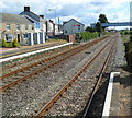
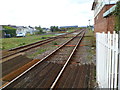
Looking east from platform 2 at Pembrey & Burry Port railway station
The station is in the centre of Burry Port, about 6km west of Llanelli station on the West Wales Line. Pembrey is a village to the west of Burry Port.
Semaphore signals control the passage of trains. The arm of the signal at the end of platform 1 is in the horizontal position, meaning stop. A go signal is indicated when the arm points downwards (at an angle of about 45 degrees).
Image: © Jaggery
Taken: 15 Apr 2012
0.09 miles
10
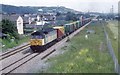
Freight train approaching Burry Port station
Seen just from the overbridge north of the station a special train heads for west Wales.
Image: © roger geach
Taken: 21 Jun 1996
0.09 miles