IMAGES TAKEN NEAR TO
Pembrey, BURRY PORT, SA16 0JS
Introduction
This page details the photographs taken nearby to SA16 0JS by members of the Geograph project.
The Geograph project started in 2005 with the aim of publishing, organising and preserving representative images for every square kilometre of Great Britain, Ireland and the Isle of Man.

There are currently over 7.5m images from over14,400 individuals and you can help contribute to the project by visiting https://www.geograph.org.uk
Image Map
Images are licensed for reuse under creativecommons.org/licenses/by-sa/2.0
Notes
- Clicking on the map will re-center to the selected point.
- The higher the marker number, the further away the image location is from the centre of the postcode.
Image Listing (3 Images Found)
Images are licensed for reuse under creativecommons.org/licenses/by-sa/2.0
Image
Details
Distance
1
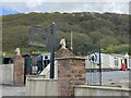
Meldan Stables
Entrance to Meldan Stables.
Image: © Alan Hughes
Taken: 5 May 2021
0.01 miles
2
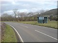
Derelict bus shelter
A curious sight on this road's corner - a derelict bus shelter. Obviously no longer in use as Carmarthenshire has long since replaced this metal style of shelter with smart plastic ones and it has no timetables attached.
Image: © Hywel Williams
Taken: 20 Feb 2009
0.04 miles
3
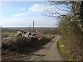
Narrow country lane
A country lane that serves nearby houses and farms.
Image: © Hywel Williams
Taken: 20 Feb 2009
0.05 miles