IMAGES TAKEN NEAR TO
Pembrey, BURRY PORT, SA16 0JG
Introduction
This page details the photographs taken nearby to SA16 0JG by members of the Geograph project.
The Geograph project started in 2005 with the aim of publishing, organising and preserving representative images for every square kilometre of Great Britain, Ireland and the Isle of Man.

There are currently over 7.5m images from over14,400 individuals and you can help contribute to the project by visiting https://www.geograph.org.uk
Image Map
Images are licensed for reuse under creativecommons.org/licenses/by-sa/2.0
Notes
- Clicking on the map will re-center to the selected point.
- The higher the marker number, the further away the image location is from the centre of the postcode.
Image Listing (6 Images Found)
Images are licensed for reuse under creativecommons.org/licenses/by-sa/2.0
Image
Details
Distance
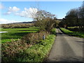
2
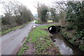
Heol fach ger Pinged / A minor road near Pinged
Heol fach a nant ddienw ger Pinged.
A minor road and an unnamed stream near Pinged.
Image: © Alan Richards
Taken: 1 Feb 2021
0.21 miles
3
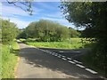
Road junction
Road junction near Pinged.
Image: © Alan Hughes
Taken: 1 Jun 2019
0.23 miles
4
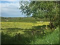
Buttercup meadow
View across buttercup meadow towards paddock with horses.
Image: © Alan Hughes
Taken: 1 Jun 2019
0.23 miles
5
Road to Pinged
The NCN 4 cycleway takes a narrow lane to the right towards Pembrey.
Image: © John M
Taken: 4 Nov 2017
0.23 miles
6
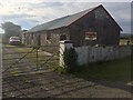
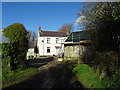
Tranquillity Farm
Farm building - in a quiet location.
Image: © Alan Hughes
Taken: 1 Jun 2019
0.24 miles