IMAGES TAKEN NEAR TO
BURRY PORT, SA16 0HD
Introduction
This page details the photographs taken nearby to SA16 0HD by members of the Geograph project.
The Geograph project started in 2005 with the aim of publishing, organising and preserving representative images for every square kilometre of Great Britain, Ireland and the Isle of Man.

There are currently over 7.5m images from over14,400 individuals and you can help contribute to the project by visiting https://www.geograph.org.uk
Image Map
Images are licensed for reuse under creativecommons.org/licenses/by-sa/2.0
Notes
- Clicking on the map will re-center to the selected point.
- The higher the marker number, the further away the image location is from the centre of the postcode.
Image Listing (32 Images Found)
Images are licensed for reuse under creativecommons.org/licenses/by-sa/2.0
Image
Details
Distance
1
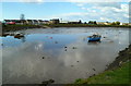
West Dock, Burry Port
Part of Burry Port Harbour. The other parts are East Dock and Outer Harbour.
Image: © Jaggery
Taken: 15 Apr 2012
0.09 miles
2
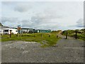
Caravan park behind the dunes
The track behind the marked post, to the right of the picture, is part of the National Cycle Network, route 4.
Image: © Rose and Trev Clough
Taken: 16 Oct 2008
0.10 miles
3
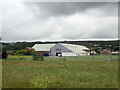
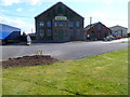
Parsons Pickle Factory, Burry Port
Parsons is the only British manufacturer of pickled cockles and mussels, as well a range of quality traditional pickles and laverbread. Originally based in Laugharne, the company moved to this modern factory in 1952.
Image: © Eirian Evans
Taken: 23 May 2022
0.13 miles
4
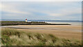
View over the dunes to Burry Port breakwater and lighthouse
Image: © Gareth James
Taken: 3 Jun 2021
0.14 miles
5
Parsons Pickles, Burry Port
This is the Ashburnham Works of Leslie A. Parsons & Sons (Burry Port) Ltd. Their products include laver bread, pickled cockles and mussels, a traditional range of pickles and a catering buffet range.
Image: © Jaggery
Taken: 15 Apr 2012
0.15 miles
6
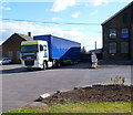
Parsons Pickles lorry, Burry Port
The lorry is parked in front of the Parsons Pickles Ashburnham Works. http://www.geograph.org.uk/photo/3622492
Image: © Jaggery
Taken: 15 Apr 2012
0.16 miles
7
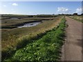
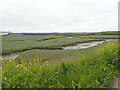
Track through wetlands
Track alongside saltmarsh at Pembrey harbour. Wales Coastal Path.
Image: © Alan Hughes
Taken: 16 Oct 2019
0.16 miles
8
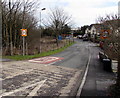
Derwydd Road, Burry Port
Derwydd Road descends from the B4311. The 30mph speed limit drops to 20mph.
Image: © Jaggery
Taken: 8 Mar 2018
0.17 miles
10
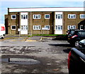
Tŷ Tan-y-Bryn, Cliff Terrace, Burry Port
In 2018 managed by Carmarthenshire County Council Housing Department, Tŷ Tan-y-Bryn is retirement housing containing 29 1-bedroom flats built in 1975. New residents must be at least 60 years old.
Image: © Jaggery
Taken: 8 Mar 2018
0.18 miles