1
Platform over a stream near a culvert in Orchard Close, Pembrey
The stream flows under the platform and into a culvert beneath Orchard Close and Heol Panteg.
Image: © Jaggery
Taken: 15 Apr 2012
0.04 miles
2
Ordnance Survey Cut Mark
This OS cut mark can be found on the wall of No1 Furnace Road. It marks a point 10.571m above mean sea level.
Image: © Adrian Dust
Taken: 8 Jan 2022
0.06 miles
3
Track on the north side of Burry Road, Pembrey
The track heads away from Burry Road near the corner of Heol Waun-Wen.
A nearby sign http://www.geograph.org.uk/photo/3618294 shows the penalties for fly tipping or littering here.
Image: © Jaggery
Taken: 15 Apr 2012
0.07 miles
4
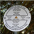
Keep Carmarthenshire Tidy, Pembrey
Located near this track. http://www.geograph.org.uk/photo/3618293 At the April 2012 date of this view, the maximum penalty for fly tipping was £50,000 and for littering £2,500. The area is covered by CCTV surveillance.
Image: © Jaggery
Taken: 15 Apr 2012
0.07 miles
5
Heol Panteg houses, Pembrey
Viewed from the corner of Heol Waun-Wen.
Image: © Jaggery
Taken: 15 Apr 2012
0.08 miles
6
Heol Panteg, Pembrey
Viewed from the corner of Orchard Close.
Image: © Jaggery
Taken: 15 Apr 2012
0.08 miles
7
Corner of Gwscwm Road and Furnace Road, Pembrey
The bilingual sign shows that Furnace Road is Heol Ffwrnes in Welsh.
Image: © Jaggery
Taken: 16 Mar 2018
0.09 miles
8
Gwscwm Road postbox, Pembrey
In the end of a long stone wall alongside the A484 Gwscwm Road on the approach to Burry Port.
Image: © Jaggery
Taken: 16 Mar 2018
0.09 miles
9
Heol Waun-Wen houses, Pembrey
Looking eastwards from the corner of Heol Panteg.
Image: © Jaggery
Taken: 15 Apr 2012
0.09 miles
10
Ordnance Survey Cut Mark
This OS cut mark can be found on the wall of No77 Gwscwm Road. It marks a point 20.842m above mean sea level.
Image: © Adrian Dust
Taken: 8 Jan 2022
0.09 miles


