IMAGES TAKEN NEAR TO
Heol Y Llan, BURRY PORT, SA16 0AP
Introduction
This page details the photographs taken nearby to Heol Y Llan, SA16 0AP by members of the Geograph project.
The Geograph project started in 2005 with the aim of publishing, organising and preserving representative images for every square kilometre of Great Britain, Ireland and the Isle of Man.

There are currently over 7.5m images from over14,400 individuals and you can help contribute to the project by visiting https://www.geograph.org.uk
Image Map
Images are licensed for reuse under creativecommons.org/licenses/by-sa/2.0
Notes
- Clicking on the map will re-center to the selected point.
- The higher the marker number, the further away the image location is from the centre of the postcode.
Image Listing (52 Images Found)
Images are licensed for reuse under creativecommons.org/licenses/by-sa/2.0
Image
Details
Distance
1
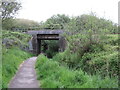
Former canal and railway route in Burry Port
Image: © Gareth James
Taken: 3 Jun 2021
0.04 miles
2
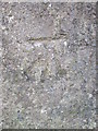
Ordnance Survey Cut Mark
This OS cut mark can be found on the NW parapet bridge on the Ashburnham Road. It marks a point 10.08m above mean sea level.
Image: © Adrian Dust
Taken: 29 Nov 2014
0.04 miles
3
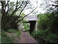
Former canal and railway route in Burry Port
Image: © Gareth James
Taken: 3 Jun 2021
0.05 miles
4
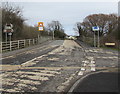
Patchy surface on the B4311, Burry Port
At and near the Derwydd Road junction viewed in March 2018.
Image: © Jaggery
Taken: 8 Mar 2018
0.05 miles
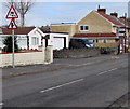
5
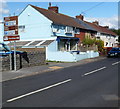
Cliff Terrace houses, Burry Port
The sign shows ahead for the harbour and long stay car park,
right for a short stay car park and the shoreline.
Image: © Jaggery
Taken: 15 Apr 2012
0.07 miles
6
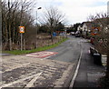
Derwydd Road, Burry Port
Derwydd Road descends from the B4311. The 30mph speed limit drops to 20mph.
Image: © Jaggery
Taken: 8 Mar 2018
0.08 miles
7
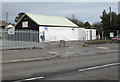
Harbour Tyres, Seaview Terrace, Burry Port
At the western end of Seaview Terrace, viewed across the B4311 Ashburnham Road.
Image: © Jaggery
Taken: 8 Mar 2018
0.10 miles
8
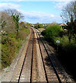
West Wales Line railway towards Pembrey & Burry Port railway station
A view east from this http://www.geograph.org.uk/photo/3622290 footbridge. Out of shot around the bend,
Pembrey & Burry Port railway station is about a kilometre from the bridge.
Image: © Jaggery
Taken: 15 Apr 2012
0.10 miles
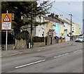
9
Warning signs alongside Cliff Terrace, Burry Port
Signs warning of a skid risk and a minor road junction face eastbound traffic on the B4311 Cliff Terrace.
Image: © Jaggery
Taken: 8 Mar 2018
0.10 miles
10
Rhesi unigol o draffig/Single file traffic sign, Ashburnham Road, Burry Port
The Welsh/English sign is alongside the B4311 Ashburnham Road at the edge of Seaview Terrace.
Image: © Jaggery
Taken: 8 Mar 2018
0.11 miles