IMAGES TAKEN NEAR TO
Elkington Road, BURRY PORT, SA16 0AB
Introduction
This page details the photographs taken nearby to Elkington Road, SA16 0AB by members of the Geograph project.
The Geograph project started in 2005 with the aim of publishing, organising and preserving representative images for every square kilometre of Great Britain, Ireland and the Isle of Man.

There are currently over 7.5m images from over14,400 individuals and you can help contribute to the project by visiting https://www.geograph.org.uk
Image Map
Images are licensed for reuse under creativecommons.org/licenses/by-sa/2.0
Notes
- Clicking on the map will re-center to the selected point.
- The higher the marker number, the further away the image location is from the centre of the postcode.
Image Listing (73 Images Found)
Images are licensed for reuse under creativecommons.org/licenses/by-sa/2.0
Image
Details
Distance
1
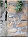
Ordnance Survey Cut Mark
This OS cut mark can be found on a brick gatepost of No107 Elkington Road. It marks a point 26.694m above mean sea level.
Image: © Adrian Dust
Taken: 29 Nov 2014
0.04 miles
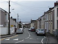
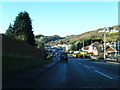
2
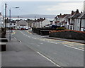
Down Stepney Road, Burry Port
Stepney Road descends southwards from Elkington Road towards the centre of Burry Port.
Image: © Jaggery
Taken: 16 Mar 2018
0.08 miles
3
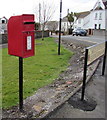
Queen Elizabeth II postbox on a Burry Port corner
Located here https://www.geograph.org.uk/photo/5878277 on the corner of Stepney Road and Elkington Road.
Image: © Jaggery
Taken: 16 Mar 2018
0.09 miles
4
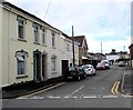
West along Park Terrace, Burry Port
From Stepney Road along Park Terrace towards Elkington Road.
Image: © Jaggery
Taken: 16 Mar 2018
0.09 miles
5
Wires over Stepney Road, Burry Port
Telephone wires radiate from poles alongside Stepney Road.
Image: © Jaggery
Taken: 16 Mar 2018
0.09 miles
6
Bus shelter on a Burry Port corner
On the corner of Stepney Road and Elkington Road.
Image: © Jaggery
Taken: 16 Mar 2018
0.10 miles
7
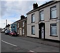
Elkington Road houses, Burry Port
At the northeast end of Elkington Road, viewed from the corner of the A484 Colby Road.
Image: © Jaggery
Taken: 16 Mar 2018
0.10 miles
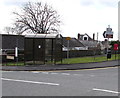
8
Ace Garage, Achddu, Burry Port
On the south side of the A484 Gwscwm Road near the corner of Bro Deri in the Achddu area of Burry Port.
Image: © Jaggery
Taken: 16 Mar 2018
0.10 miles
10
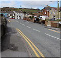
Up Stepney Road, Burry Port
Stepney Road ascends towards Elkington Road.
Image: © Jaggery
Taken: 16 Mar 2018
0.11 miles