IMAGES TAKEN NEAR TO
Mansel Street, SWANSEA, SA1 5TN
Introduction
This page details the photographs taken nearby to Mansel Street, SA1 5TN by members of the Geograph project.
The Geograph project started in 2005 with the aim of publishing, organising and preserving representative images for every square kilometre of Great Britain, Ireland and the Isle of Man.

There are currently over 7.5m images from over14,400 individuals and you can help contribute to the project by visiting https://www.geograph.org.uk
Image Map
Images are licensed for reuse under creativecommons.org/licenses/by-sa/2.0
Notes
- Clicking on the map will re-center to the selected point.
- The higher the marker number, the further away the image location is from the centre of the postcode.
Image Listing (180 Images Found)
Images are licensed for reuse under creativecommons.org/licenses/by-sa/2.0
Image
Details
Distance
1
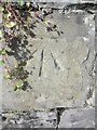
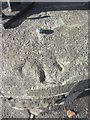
Ordnance Survey Cut Mark
This OS cut mark can be found on the wall of No55 Mansel Street. It marks a point 22.793m above mean sea level.
Image: © Adrian Dust
Taken: 29 Oct 2013
0.05 miles
2
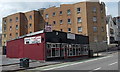
Nawab, Swansea
Indian cuisine restaurant & takeaway in Christina Street, near the corner of The Kingsway.
Image: © Jaggery
Taken: 27 Apr 2014
0.07 miles
3
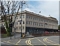
Tŷ Gwalia, Swansea
Tŷ Gwalia, 7-13 The Kingsway, is the Swansea office of Grŵp Gwalia Cyf, a major provider of social housing and care services in south and mid Wales. Gwalia manages more than 10,000 units of accommodation.
Image: © Jaggery
Taken: 27 Apr 2014
0.08 miles
4
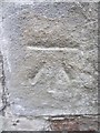
Ordnance Survey Cut Mark
This OS cut mark can be found on a garage on Heathfield. It marks a point 42.303m above mean sea level.
Image: © Adrian Dust
Taken: 31 Oct 2013
0.08 miles
5
Tŷ Gwalia, Swansea
Tŷ Gwalia, 7-13 The Kingsway, is the Swansea office of Grŵp Gwalia Cyf, a major provider of social housing and care services in south and mid Wales. Gwalia manages more than 10,000 units of accommodation.
Image: © Jaggery
Taken: 11 Mar 2012
0.09 miles
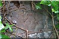
6
Ordnance Survey Rivet
This OS rivet can be found on the wall of No144 Walter Road. It marks a point 22.186m above mean sea level.
Image: © Adrian Dust
Taken: 29 Oct 2013
0.09 miles
7
Ordnance Survey Cut Mark
This OS cut mark can be found on the wall NW side of Carlton Terrace. It marks a point 27.5478m above mean sea level.
Image: © Adrian Dust
Taken: 5 Dec 2018
0.10 miles
8
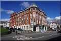
Northampton Lane side of the YMCA building, Swansea
Viewed across Page Street. Northampton Lane is on the left. The name inscribed above the doorway behind the cars is LLEWELYN HALL. http://www.geograph.org.uk/photo/4025986 to a front view of the YMCA building.
Image: © Jaggery
Taken: 27 Apr 2014
0.10 miles
9
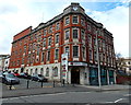
YMCA and Llewelyn Hall, Swansea
Dated 1912, the 4-storey red brick and Portland stone building occupies a large site
of the corner of St Helens Road and Page Street. Later additions to the building
include Llewelyn Hall (1920), on the Northampton Lane http://www.geograph.org.uk/photo/4025995 side of the building.
Image: © Jaggery
Taken: 27 Apr 2014
0.11 miles
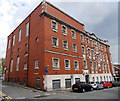
10
YMCA building
Built in 1912 for the YMCA and still occupied by that organisation.
Image: © Bill Boaden
Taken: 5 Apr 2016
0.11 miles