IMAGES TAKEN NEAR TO
Walter Road, SWANSEA, SA1 5RT
Introduction
This page details the photographs taken nearby to Walter Road, SA1 5RT by members of the Geograph project.
The Geograph project started in 2005 with the aim of publishing, organising and preserving representative images for every square kilometre of Great Britain, Ireland and the Isle of Man.

There are currently over 7.5m images from over14,400 individuals and you can help contribute to the project by visiting https://www.geograph.org.uk
Image Map (Loading...)


Getting Data...Please wait
Leaflet Map data © OpenStreetMap
Images are licensed for reuse under creativecommons.org/licenses/by-sa/2.0
Notes
- Clicking on the map will re-center to the selected point.
- The higher the marker number, the further away the image location is from the centre of the postcode.
Image Listing (137 Images Found)
Images are licensed for reuse under creativecommons.org/licenses/by-sa/2.0
Image
Details
Distance
1
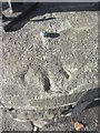
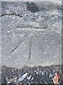
Ordnance Survey Rivet
This OS rivet can be found on the wall of No144 Walter Road. It marks a point 22.186m above mean sea level.
Image: © Adrian Dust
Taken: 29 Oct 2013
0.02 miles
2
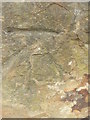
Ordnance Survey Cut Mark
This OS cut mark can be found on the wall between No1 & No2 Calvert Terrace. It marks a point 24.649m above mean sea level.
Image: © Adrian Dust
Taken: 16 Oct 2012
0.04 miles
3
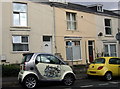
"Student Digz"
No prizes for guessing who lives in these terraced houses in Page Street nowadays.
Image: © Natasha Ceridwen de Chroustchoff
Taken: 21 Oct 2009
0.05 miles
4
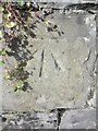
Ordnance Survey Cut Mark
This OS cut mark can be found on the wall of No55 Mansel Street. It marks a point 22.793m above mean sea level.
Image: © Adrian Dust
Taken: 29 Oct 2013
0.06 miles
5
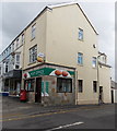
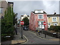
Walter Road Post Office, Swansea
At 12 Walter Road, on the corner of George Street.
Image: © Jaggery
Taken: 27 Apr 2014
0.06 miles
6
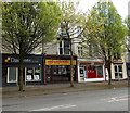
New Goldfinch, Swansea
Chinese Cantonese takeaway at 16 Walter Road.
Image: © Jaggery
Taken: 27 Apr 2014
0.08 miles
7
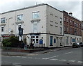
The Tenby in Swansea
Pub on the corner of Walter Road and Humphrey Street. The Salisbury http://www.geograph.org.uk/photo/3958245 is on the left.
Image: © Jaggery
Taken: 27 Apr 2014
0.09 miles
8
Ordnance Survey Cut Mark
This OS cut mark can be found on the wall of No10 George Street. It marks a point 16.066m above mean sea level.
Image: © Adrian Dust
Taken: 19 Nov 2013
0.09 miles
9
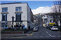
Constitution Hill
A direct route to the housing up the hill on Terrace Road.
Image: © Bill Boaden
Taken: 5 Apr 2016
0.09 miles
10
Hanover Street
At its junction with Constitution Hill, a famous Swansea landmark which has recently been improved. The surrounding houses here on the slope of Townhill are on the whole rather shabby, many being multi-occupied.
Hanover Street (formerly St George's Street) was the southern terminus of the short, and short-lived, cablecar tramway that run up and down Constitution Hill from 1898 to 1900 or thereabouts. See http://www.tramwayinfo.com/Tramframe.htm?http://www.tramwayinfo.com/Cards/Postc40.htm
Image: © Natasha Ceridwen de Chroustchoff
Taken: 21 Oct 2009
0.09 miles