1
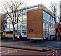
Trinity Building in central Swansea
Swansea NHS Trust Central Clinic on the corner of Orchard Street and Pleasant Street.
Image: © Jaggery
Taken: 6 Dec 2013
0.02 miles
2
Bendy bus in Orchard Street, Swansea
Using a designated Metro Bus lane, the First FTRMetro bus is on route 4 to the university. Among the features of the FTRMetro route are priority for bendy buses at traffic lights and access through the university and Singleton Hospital which is restricted for other traffic. When I travelled on a similar bus a few minutes earlier, I was surprised to see an old-fashioned feature on a 21st century bus.
The fares were being collected by a conductor, not the driver.
Image: © Jaggery
Taken: 6 Dec 2013
0.02 miles
3
Former Ragged School in Swansea
On the corner of Pleasant Street and Richard's Place, now Swansea Spirit Healing and Psychic Educational Centre. The inscription in stone over the entrance shows that this is the 1911 rebuild
of the first Ragged School built in 1847 to care for and educate boys and girls of the poor.
Image: © Jaggery
Taken: 6 Dec 2013
0.03 miles
4
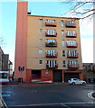
Madison House, Swansea
City centre flats at 34 Orchard Street, viewed from Pleasant Street.
Image: © Jaggery
Taken: 6 Dec 2013
0.03 miles
5
Across High street from King's Lane
The lane ahead connects with Orchard Street.
Image: © Deborah Tilley
Taken: 26 Jul 2008
0.04 miles
6
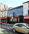
Three shops on the corner of Kings Lane and High Street, Swansea
Nearest the camera, the corner shop is Cogger's Newsagents.
Next door is Delight takeaway.
The shop on the left is Crumbs, sandwich bar and cafe.
Image: © Jaggery
Taken: 26 Feb 2012
0.04 miles
7
The Kings Arms Tavern, Swansea
Pub at 26 High Street, on the corner of King Street, viewed from the corner of Kings Lane.
Image: © Jaggery
Taken: 26 Feb 2012
0.04 miles
8
Adam & Eve, Swansea
High Street pub at number 207. https://www.geograph.org.uk/photo/2822383 to the name sign.
Image: © Jaggery
Taken: 26 Feb 2012
0.04 miles
9
Adam & Eve pub sign, Swansea
Strategically-placed vegetation preserves the modesty of
Adam and Eve in the sign hanging from the wall of the High Street pub. http://www.geograph.org.uk/photo/2822370
Image: © Jaggery
Taken: 26 Feb 2012
0.04 miles
10
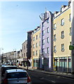
Mackworth Court, Swansea
The modern block of High Street flats occupies the site of The Angel Hotel, built in 1889. The Angel was later renamed the Mackworth Hotel, which closed in 1967 and was demolished in the 1970s.
Image: © Jaggery
Taken: 26 Feb 2012
0.04 miles


