IMAGES TAKEN NEAR TO
Heol Llanelli, LLANELLI, SA15 5TU
Introduction
This page details the photographs taken nearby to Heol Llanelli, SA15 5TU by members of the Geograph project.
The Geograph project started in 2005 with the aim of publishing, organising and preserving representative images for every square kilometre of Great Britain, Ireland and the Isle of Man.

There are currently over 7.5m images from over14,400 individuals and you can help contribute to the project by visiting https://www.geograph.org.uk
Image Map (Loading...)


Getting Data...Please wait
Leaflet Map data © OpenStreetMap
Images are licensed for reuse under creativecommons.org/licenses/by-sa/2.0
Notes
- Clicking on the map will re-center to the selected point.
- The higher the marker number, the further away the image location is from the centre of the postcode.
Image Listing (26 Images Found)
Images are licensed for reuse under creativecommons.org/licenses/by-sa/2.0
Image
Details
Distance
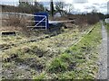
1

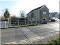
Level crossing at dismantled railway, Pont-iets
Image: © John Lord
Taken: 17 Oct 2008
0.03 miles
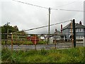
2
Disused level crossing at Pontyates
The last train over this section of the Burry Port & Gwendraeth Valley line ran in 1996.
Image: © Gareth James
Taken: 26 Mar 2022
0.05 miles
3
Redundant level crossing, Pontyates
For a location shot, see http://www.geograph.org.uk/photo/1010634 . This is on the disused Burry Port and Gwendraeth Valley Railway, which ran from near Llanelli to Cwm Mawr. Constructed to transport coal from local mines, it also carried passengers until 1953, and there was a station at Pontyates. The line closed in 1996 when the mines ceased operating. However, a group of enthusiasts has already started restoration work on part of the railway, and hope to be operating trains again in the near future http://www.bpgv.co.uk/ .
Image: © Rose and Trev Clough
Taken: 14 Oct 2008
0.05 miles
4
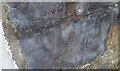
Ordnance Survey Cut Mark
This OS cut mark can be found on Mount Pleasant, south side of the road. It marks a point 28.868m above mean sea level.
Image: © Adrian Dust
Taken: 30 Mar 2021
0.05 miles

6
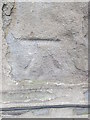
Ordnance Survey Cut Mark
This OS cut mark can be found on the front of the Rhwyth Inn. It marks a point 12.268m above mean sea level.
Image: © Adrian Dust
Taken: 11 May 2014
0.05 miles
7
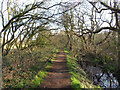
Footpath beside disused railway line near Pontyates
The last train ran along this section of the Burry Port & Gwendraeth Valley line in 1996.
Image: © Gareth James
Taken: 26 Mar 2022
0.06 miles
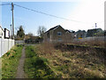
8
Disused railway
Remains of the old railway line between Pontiets and Kidwelly.
Image: © Alan Hughes
Taken: 16 Mar 2021
0.07 miles
9
Site of former station in Pontyates
The rails are still in situ and station platform on the right, but the last train passed over 25 years ago.
Image: © Gareth James
Taken: 26 Mar 2022
0.07 miles
10
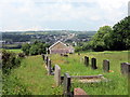
Mynwent Capel Tabernacl / Tabernacle Chapel graveyard
Mynwent Capel Tabernacl gyda phentre Pontiets yn y pellter.
Tabernacle Chapel burial ground with the village of Pontyates (trans. Yates' bridge) in the distance.
Image: © Alan Richards
Taken: 4 Jun 2018
0.07 miles