IMAGES TAKEN NEAR TO
Lime Grove, LLANELLI, SA15 5SW
Introduction
This page details the photographs taken nearby to Lime Grove, SA15 5SW by members of the Geograph project.
The Geograph project started in 2005 with the aim of publishing, organising and preserving representative images for every square kilometre of Great Britain, Ireland and the Isle of Man.

There are currently over 7.5m images from over14,400 individuals and you can help contribute to the project by visiting https://www.geograph.org.uk
Image Map
Images are licensed for reuse under creativecommons.org/licenses/by-sa/2.0
Notes
- Clicking on the map will re-center to the selected point.
- The higher the marker number, the further away the image location is from the centre of the postcode.
Image Listing (3 Images Found)
Images are licensed for reuse under creativecommons.org/licenses/by-sa/2.0
Image
Details
Distance
1

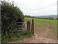
Llwybr cyhoeddus i'r B4309 / A public path to the B4309
Llwybr cyhoeddus yn mynd i gyfeiriad y B4309.
A public footpath heading towards the B4309.
Image: © Alan Richards
Taken: 20 Aug 2019
0.14 miles
2
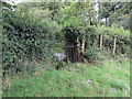
Llwybr ger Ffarm Pant y Parchell / Path near Pant y Parchell Farm
Llwybr cyhoeddus ger Ffarm Pant y Parchell.
A public footpath near Pant y Parchell Farm (trans. piglet hollow)
Image: © Alan Richards
Taken: 20 Aug 2019
0.15 miles
3
Llwybr yn cyrraedd yr heol / A path joining a road
Llwybr cyhoeddus yn nesau at heol fach sy'n arwain at Bont Henri.
A public footpath approaching a minor road heading towards Pont Henry (trans. Henry's bridge).
Image: © Alan Richards
Taken: 20 Aug 2019
0.23 miles