IMAGES TAKEN NEAR TO
Heol Y Meinciau, LLANELLI, SA15 5RT
Introduction
This page details the photographs taken nearby to Heol Y Meinciau, SA15 5RT by members of the Geograph project.
The Geograph project started in 2005 with the aim of publishing, organising and preserving representative images for every square kilometre of Great Britain, Ireland and the Isle of Man.

There are currently over 7.5m images from over14,400 individuals and you can help contribute to the project by visiting https://www.geograph.org.uk
Image Map (Loading...)


Getting Data...Please wait
Leaflet Map data © OpenStreetMap
Images are licensed for reuse under creativecommons.org/licenses/by-sa/2.0
Notes
- Clicking on the map will re-center to the selected point.
- The higher the marker number, the further away the image location is from the centre of the postcode.
Image Listing (6 Images Found)
Images are licensed for reuse under creativecommons.org/licenses/by-sa/2.0
Image
Details
Distance
1
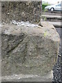
Ordnance Survey Pivot
This OS pivot can be found on the south angle of the Square & Compass. It marks a point 29.599m above mean sea level. http://www.geograph.org.uk/photo/3973077
Image: © Adrian Dust
Taken: 11 May 2014
0.02 miles
2
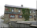
Square & Compass, Pontyates
There is an Ordnance Survey pivot on the south angle of the Public House. http://www.geograph.org.uk/photo/3973072
Image: © Adrian Dust
Taken: 11 May 2014
0.02 miles
4
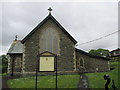
St Mary's Church
There is an Ordnance Survey cut mark on the north angle. http://www.geograph.org.uk/photo/3973066
Image: © Adrian Dust
Taken: 11 May 2014
0.11 miles
5
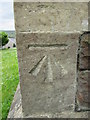
Ordnance Survey Cut Mark
This OS cut mark can be found on St Mary's Church. It marks a point 48.152m above mean sea level. http://www.geograph.org.uk/photo/3973069
Image: © Adrian Dust
Taken: 11 May 2014
0.12 miles