IMAGES TAKEN NEAR TO
Ponthenry, LLANELLI, SA15 5RE
Introduction
This page details the photographs taken nearby to SA15 5RE by members of the Geograph project.
The Geograph project started in 2005 with the aim of publishing, organising and preserving representative images for every square kilometre of Great Britain, Ireland and the Isle of Man.

There are currently over 7.5m images from over14,400 individuals and you can help contribute to the project by visiting https://www.geograph.org.uk
Image Map
Images are licensed for reuse under creativecommons.org/licenses/by-sa/2.0
Notes
- Clicking on the map will re-center to the selected point.
- The higher the marker number, the further away the image location is from the centre of the postcode.
Image Listing (18 Images Found)
Images are licensed for reuse under creativecommons.org/licenses/by-sa/2.0
Image
Details
Distance
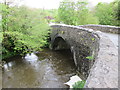
1
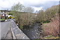
Pont Henry passing over the Gwendraith Fawr
Image: © Mick Lobb
Taken: 7 Apr 2009
0.02 miles
3
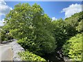
Gwendraeth Fawr
Bridge over the Gwendraeth Fawr at Pont Henri.
Image: © Alan Hughes
Taken: 8 Jun 2020
0.06 miles
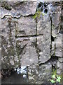
4
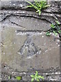
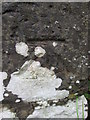
Ordnance Survey Cut Mark
This OS cut mark can be found on the SW parapet of Pont-Henri. It marks a point 19.599m above mean sea level. http://www.geograph.org.uk/photo/3972815
Image: © Adrian Dust
Taken: 11 May 2014
0.07 miles
5
Pont-Henri & Gwendraeth Fawr
There is an Ordnance Survey cut mark on the SW parapet. http://www.geograph.org.uk/photo/3972808
Image: © Adrian Dust
Taken: 11 May 2014
0.08 miles
6
Ordnance Survey Cut Mark
This OS cut mark can be found on the East parapet of the bridge over a tributary of the Aber Lledle. It marks a point 25.682m above mean sea level.
Image: © Adrian Dust
Taken: 11 May 2014
0.09 miles
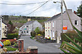
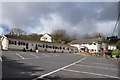
8
The Incline Inn, Ponthenry
Looking up at the Incline Inn in Ponthenry from the disused railway.
Image: © Paul Glasper
Taken: 11 Aug 2012
0.16 miles
9
Ordnance Survey Cut Mark
This OS cut mark can be found on the NE parapet of the railway bridge. It marks a point 26.923m above mean sea level. http://www.geograph.org.uk/photo/3972803
Image: © Adrian Dust
Taken: 11 May 2014
0.18 miles
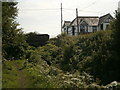
10
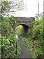
Pont-Henri Railway Bridge
There is an Ordnance Survey cut mark on the NE parapet. http://www.geograph.org.uk/photo/3972794
Image: © Adrian Dust
Taken: 11 May 2014
0.18 miles