IMAGES TAKEN NEAR TO
Haulfryn, LLANELLI, SA15 5DN
Introduction
This page details the photographs taken nearby to Haulfryn, SA15 5DN by members of the Geograph project.
The Geograph project started in 2005 with the aim of publishing, organising and preserving representative images for every square kilometre of Great Britain, Ireland and the Isle of Man.

There are currently over 7.5m images from over14,400 individuals and you can help contribute to the project by visiting https://www.geograph.org.uk
Image Map (Loading...)


Getting Data...Please wait
Leaflet Map data © OpenStreetMap
Images are licensed for reuse under creativecommons.org/licenses/by-sa/2.0
Notes
- Clicking on the map will re-center to the selected point.
- The higher the marker number, the further away the image location is from the centre of the postcode.
Image Listing (7 Images Found)
Images are licensed for reuse under creativecommons.org/licenses/by-sa/2.0
Image
Details
Distance
1
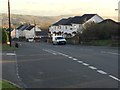
Bancffosfelen High Street
Houses line the main street in Bancffosfelen.
Image: © Alan Hughes
Taken: 5 Nov 2017
0.05 miles
2
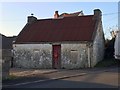
No 115A
Is this a residence with an address? Unlikely - probably an outbuilding belonging to 115 Heol y Banc.
Image: © Alan Hughes
Taken: 5 Nov 2017
0.06 miles
3
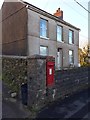
Postbox at Bancffosfelen
A Post Office is indicated on the OS map, but this postbox was all I could find.
Image: © Alan Hughes
Taken: 5 Nov 2017
0.07 miles
4
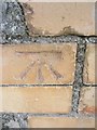
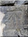
Ordnance Survey Cut Mark
This OS cut mark can be found on the wall of No68 Heol Y Banc. It marks a point 169.63m above mean sea level.
Image: © Adrian Dust
Taken: 8 Mar 2014
0.14 miles
5
Ordnance Survey Cut Mark
This OS cut mark can be found on the school wall at the junction. It marks a point 203.55m above mean sea level.
Image: © Adrian Dust
Taken: 8 Mar 2014
0.15 miles
6
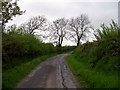
Trees on country road north of Trallwm
Country road near Bancffosfelen
Image: © John Duckfield
Taken: 13 May 2009
0.19 miles
7
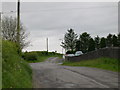
Leaving Bancffosfelen to the south west
Image: © John Duckfield
Taken: 13 May 2009
0.22 miles