IMAGES TAKEN NEAR TO
Five Roads, LLANELLI, SA15 5BQ
Introduction
This page details the photographs taken nearby to SA15 5BQ by members of the Geograph project.
The Geograph project started in 2005 with the aim of publishing, organising and preserving representative images for every square kilometre of Great Britain, Ireland and the Isle of Man.

There are currently over 7.5m images from over14,400 individuals and you can help contribute to the project by visiting https://www.geograph.org.uk
Image Map (Loading...)


Getting Data...Please wait
Leaflet Map data © OpenStreetMap
Images are licensed for reuse under creativecommons.org/licenses/by-sa/2.0
Notes
- Clicking on the map will re-center to the selected point.
- The higher the marker number, the further away the image location is from the centre of the postcode.
Image Listing (4 Images Found)
Images are licensed for reuse under creativecommons.org/licenses/by-sa/2.0
Image
Details
Distance
2
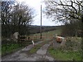
Uninviting farm gate
The sign on this farm gate reads "DO NOT ENTER".
Image: © Hywel Williams
Taken: 11 Apr 2008
0.08 miles
3
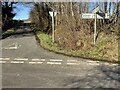
Crossroads at Sylen
A minor road to Pontyberem crosses the Pontiets to Llanelli road.
Image: © Alan Hughes
Taken: 16 Mar 2021
0.18 miles
4
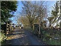
Entrance to Sylen House
A public footpath leads past the house towards Ffarm Fach and Myrtle Hill.
Image: © Alan Hughes
Taken: 16 Mar 2021
0.21 miles