IMAGES TAKEN NEAR TO
Parc Heol Ddu, Pen-y-Mynydd, LLANELLI, SA15 4SB
Introduction
This page details the photographs taken nearby to Parc Heol Ddu, Pen-y-Mynydd, SA15 4SB by members of the Geograph project.
The Geograph project started in 2005 with the aim of publishing, organising and preserving representative images for every square kilometre of Great Britain, Ireland and the Isle of Man.

There are currently over 7.5m images from over14,400 individuals and you can help contribute to the project by visiting https://www.geograph.org.uk
Image Map (Loading...)


Getting Data...Please wait
Leaflet Map data © OpenStreetMap
Images are licensed for reuse under creativecommons.org/licenses/by-sa/2.0
Notes
- Clicking on the map will re-center to the selected point.
- The higher the marker number, the further away the image location is from the centre of the postcode.
Image Listing (8 Images Found)
Images are licensed for reuse under creativecommons.org/licenses/by-sa/2.0
Image
Details
Distance
1
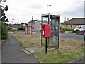
Post box, phone box, bus shelter
Street scene at the junction between Dythel Park and Trimsaran Road.
Image: © Richard Dorrell
Taken: 15 Jun 2013
0.04 miles
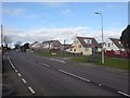
2
Heol Ddu, Pen-y-Mynydd
A residential road viewed from the junction with Parc Heol Ddu.
Image: © Richard Dorrell
Taken: 15 Jun 2013
0.05 miles
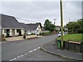
3
Pen-y-Mynydd hamlet
The name of this hamlet translates to top of the mountain.
Image: © Hywel Williams
Taken: 23 Jan 2007
0.06 miles
5
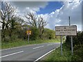
Entrance to Pen-y-Mynydd
Road sign on the B4308 from Trimsaran.
Image: © Alan Hughes
Taken: 5 May 2021
0.11 miles
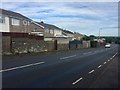
6
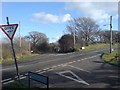
Road junction just south of Trimsaran
A road junction on the B4308 just south of Trimsaran.
Image: © Hywel Williams
Taken: 23 Jan 2007
0.15 miles
7
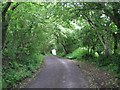
Rural road north of Pen-y-Mynydd
This patch of woodland lies just north of the village.
Image: © Richard Dorrell
Taken: 15 Jun 2013
0.16 miles
8
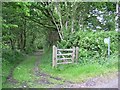
Bridleway from Pen-y-Mynydd
This is the start of a bridleway leading north from Heol Rehoboth, close to the village of Pen-y-Mynydd. The track passes through land that was not so long ago an opencast coal mine, though little trace of the former workings exist today.
Image: © Richard Dorrell
Taken: 15 Jun 2013
0.25 miles