IMAGES TAKEN NEAR TO
Pentrepoeth Road, LLANELLI, SA15 4NR
Introduction
This page details the photographs taken nearby to Pentrepoeth Road, SA15 4NR by members of the Geograph project.
The Geograph project started in 2005 with the aim of publishing, organising and preserving representative images for every square kilometre of Great Britain, Ireland and the Isle of Man.

There are currently over 7.5m images from over14,400 individuals and you can help contribute to the project by visiting https://www.geograph.org.uk
Image Map
Images are licensed for reuse under creativecommons.org/licenses/by-sa/2.0
Notes
- Clicking on the map will re-center to the selected point.
- The higher the marker number, the further away the image location is from the centre of the postcode.
Image Listing (13 Images Found)
Images are licensed for reuse under creativecommons.org/licenses/by-sa/2.0
Image
Details
Distance
1
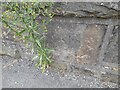
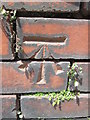
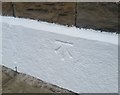
Ordnance Survey Cut Mark
This inverted OS cut mark can be found on the NE parapet of the railway bridge. It marked a point 43.599m above mean sea level.
Image: © Adrian Dust
Taken: 28 Aug 2022
0.03 miles
2
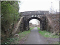
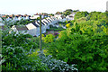
Lon y Dderwen bridge over the Swiss Valley Cycle Trail in Felinfoel
Image: © Gareth James
Taken: 18 Mar 2023
0.03 miles
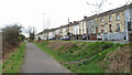
3

The last house on Terras Tyisha (Tyisha Terrace)
Image: © David Lally
Taken: 10 Jun 2013
0.04 miles
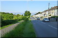
4
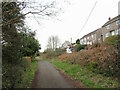
Swiss Valley Cycle Trail beside Pentrepoeth Road
The cycle path was once a railway line.
Image: © Gareth James
Taken: 18 Mar 2023
0.09 miles
7
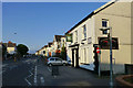
Dimpath Hotel
Beside the A476 on the northern outskirts of Llanelli.
Image: © David Lally
Taken: 10 Jun 2013
0.14 miles
8
Ordnance Survey Cut Mark
This OS cut mark can be found on the wall of No169 Felinfoel Road. It marks a point 48.198m above mean sea level.
Image: © Adrian Dust
Taken: 22 Jun 2014
0.17 miles
9
Swiss Valley Cycle Trail through Felinfoel
Image: © Gareth James
Taken: 18 Mar 2023
0.20 miles
10
Ordnance Survey Cut Mark
This OS cut mark can be found on No200 Felin-foel Road. It marks a point 37.012m above mean sea level.
Image: © Adrian Dust
Taken: 3 Jun 2020
0.22 miles