IMAGES TAKEN NEAR TO
Adulam Row, LLANELLI, SA15 4LR
Introduction
This page details the photographs taken nearby to Adulam Row, SA15 4LR by members of the Geograph project.
The Geograph project started in 2005 with the aim of publishing, organising and preserving representative images for every square kilometre of Great Britain, Ireland and the Isle of Man.

There are currently over 7.5m images from over14,400 individuals and you can help contribute to the project by visiting https://www.geograph.org.uk
Image Map
Images are licensed for reuse under creativecommons.org/licenses/by-sa/2.0
Notes
- Clicking on the map will re-center to the selected point.
- The higher the marker number, the further away the image location is from the centre of the postcode.
Image Listing (39 Images Found)
Images are licensed for reuse under creativecommons.org/licenses/by-sa/2.0
Image
Details
Distance
1
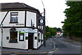
Royal Oak Inn
Corner pub in Felinfoel. Beside the A476. Cannot vouch for the food, but the beer was lovely!
Image: © David Lally
Taken: 9 Jun 2013
0.03 miles
2
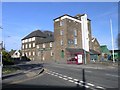
Felinfoel Brewery
One of two breweries traditionally associated with Llanelli, this is the only one remaining after the Brains brewery closed.
Image: © Hywel Williams
Taken: 19 Apr 2007
0.04 miles
3
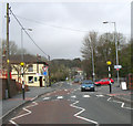
Mini roundabout
Looking North West in the Felinfoel area of Llanelli.
Image: © Dara Jasumani
Taken: 31 Mar 2006
0.06 miles
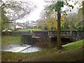
4
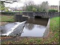
Felinfoel Baptismal Pool
Here the river Lliedi passes under the A476 main road. A weir forms the pool and access from up on the bridge would be down the steps by the pictured railings. A plaque by the gate at the top of the railings says that the Lliedei has been used for baptisms since the 18th century.
Image: © Nigel Davies
Taken: 26 Nov 2011
0.06 miles
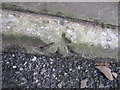
5
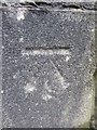
Ordnance Survey Cut Mark
This OS cut mark can be found on the SE parapet of the bridge over the Afon Lliedi. It marks a point 33.86m above mean sea level.
Image: © Adrian Dust
Taken: 8 Feb 2014
0.07 miles
6
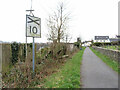
Old railway sign on the Swiss Valley Cycle Trail
The sign warned drivers of trains of the approach to a level crossing. The route is now the Swiss Valley Cycle Trail.
Image: © Gareth James
Taken: 18 Mar 2023
0.07 miles
7
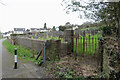
Cemetery in Felinfoel beside the Swiss Valley Cycle Trail
Image: © Gareth James
Taken: 18 Mar 2023
0.07 miles
8
River Lliedi
The Non-Conformists from nearby Adulam Chapel once baptised their flock at this place.
Image: © Deborah Tilley
Taken: 9 Nov 2008
0.07 miles
9
Ordnance Survey Pivot
This OS Pivot can be found on a window sill at ground level of the brewery building. It marks a point 31.58m above mean sea level.
Image: © Adrian Dust
Taken: 8 Feb 2014
0.08 miles
10
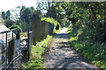
Swiss Valley Trail cycle track, Felinfoel
Cycle track on former Llanelli & Mynydd Mawr Mineral Railway.
Image: © M J Roscoe
Taken: 10 Oct 2021
0.08 miles