IMAGES TAKEN NEAR TO
Rhodfa Llwyn-Eithin, LLANELLI, SA15 4HN
Introduction
This page details the photographs taken nearby to Rhodfa Llwyn-Eithin, SA15 4HN by members of the Geograph project.
The Geograph project started in 2005 with the aim of publishing, organising and preserving representative images for every square kilometre of Great Britain, Ireland and the Isle of Man.

There are currently over 7.5m images from over14,400 individuals and you can help contribute to the project by visiting https://www.geograph.org.uk
Image Map (Loading...)


Getting Data...Please wait
Leaflet Map data © OpenStreetMap
Images are licensed for reuse under creativecommons.org/licenses/by-sa/2.0
Notes
- Clicking on the map will re-center to the selected point.
- The higher the marker number, the further away the image location is from the centre of the postcode.
Image Listing (18 Images Found)
Images are licensed for reuse under creativecommons.org/licenses/by-sa/2.0
Image
Details
Distance
1
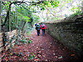
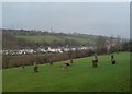
Tuag at Bentre-Poeth / Towards Pentre-Poeth
Cerddwyr yn dilyn llwybr cyhoeddus i gyfeiriad Pentre-Poeth.
Walkers following a path in the direction of Pentre-Poeth (trans. burnt homestead).
Image: © Alan Richards
Taken: 1 May 2016
0.06 miles
2
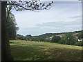
Parc Howard
Gorsedd circle in the foreground and Furnace in the distance.
Image: © Alan Hughes
Taken: 1 Jun 2019
0.07 miles
3
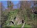
Raby's Furnace at Furnace, Llanelli
This grade II* listed building is the furnace that gives this part of Llanelli its name. It was part of a larger ironworks built in 1793. This view is from the east pavement of the adjacent B4309 main road to Pontiets.
More details: http://www.llanellich.org.uk/projects/buildings/97-a-brief-history-of-rabys-furnace http://cadwpublic-api.azurewebsites.net/reports/listedbuilding/FullReport?lang=en&id=11870
Image: © Nigel Davies
Taken: 2 Apr 2017
0.12 miles
4
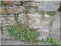
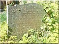
Ordnance Survey Cut Mark
This OS cut mark can be found on the wall NW side of Ynys-y-cwm Road. It marks a point 22.753m above mean sea level.
Image: © Adrian Dust
Taken: 28 Aug 2022
0.16 miles
5
The Gorsedd, Parc Howard
The small stone circle in the foreground is associated with The National Eisteddfod, an annual welsh cultural festival that takes place in different Welsh towns. Llanelli hosted the Eisteddfod in 1895, 1903, 1930, 1962 and 2000. A new gorsedd circle Image was built for the 2000 Eisteddfod - the one pictured here has been used for several previous Eisteddfods.
This picture recreates a picture taken for the Frith collection, taken around 1955. http://www.francisfrith.com/search/wales/dyfed/llanelli/photos/llanelli_L73066.htm
Image: © Hywel Williams
Taken: 9 Jan 2007
0.17 miles
6
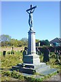
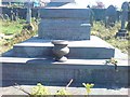
Stepney family memorial
In the cemetery linked to the parish church.
Image: © Deborah Tilley
Taken: 19 Apr 2009
0.20 miles