IMAGES TAKEN NEAR TO
Pen Y Wern, LLANELLI, SA15 4DG
Introduction
This page details the photographs taken nearby to Pen Y Wern, SA15 4DG by members of the Geograph project.
The Geograph project started in 2005 with the aim of publishing, organising and preserving representative images for every square kilometre of Great Britain, Ireland and the Isle of Man.

There are currently over 7.5m images from over14,400 individuals and you can help contribute to the project by visiting https://www.geograph.org.uk
Image Map
Images are licensed for reuse under creativecommons.org/licenses/by-sa/2.0
Notes
- Clicking on the map will re-center to the selected point.
- The higher the marker number, the further away the image location is from the centre of the postcode.
Image Listing (10 Images Found)
Images are licensed for reuse under creativecommons.org/licenses/by-sa/2.0
Image
Details
Distance
1
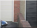
Ordnance Survey Cut Mark
This OS cut mark can be found on the garage of No78 Denham Avenue. It marks a point 9.6286m above mean sea level.
Image: © Adrian Dust
Taken: 15 Jan 2015
0.06 miles
2
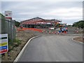
New building for Furnace Primary School
Under construction by Atkins, on behalf of Carmarthen County Council, and due to open in Spring 2015, this is the skeleton of the new Furnace Welsh Medium Primary School. The new school will replace the existing school, which is located close by, and is currently housed in one old building (which will be retained and converted into a house) and several temporary classrooms. The view here is from an entrance from Denham Avenue.
Image: © Richard Dorrell
Taken: 17 Jun 2013
0.11 miles
3
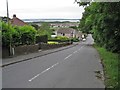
Denham Avenue, Sandy
The road drops down from its junction with the B4038 Cwmbach Road to meet the A484 in Sandy.
Image: © Richard Dorrell
Taken: 17 Jun 2013
0.11 miles
4
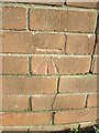
Ordnance Survey Cut Mark
This OS cut mark can be found on the wall of No4 St Margaret's Drive. It marks a point 28.499m above mean sea level.
Image: © Adrian Dust
Taken: 15 Jan 2015
0.12 miles
5
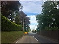
Temporary traffic lights
Roadworks on the B4803 near Furnace.
Image: © Alan Hughes
Taken: 1 Jun 2019
0.17 miles
6
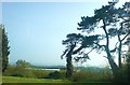
Views over Stradey Park
From St Margaret's Drive.
Image: © Deborah Tilley
Taken: 18 Apr 2009
0.17 miles
7
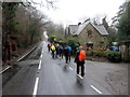
Cerdded ar hyd y B4308 / Walking along the B4308
Cerddwyr yn dilyn y B4308 wrth y mynediad i Gastell y Strade.
Walkers following the B4308 at the entrance to Stradey Castle
Image: © Alan Richards
Taken: 28 Jan 2018
0.17 miles
8
Ordnance Survey Cut Mark
This OS cut mark can be found on the wall on the south of Cwmbach Road. It marks a point 40.99m above mean sea level.
Image: © Adrian Dust
Taken: 15 Jan 2015
0.18 miles
9
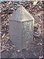
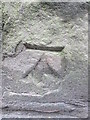
Old Milestone by the B4308, Cwmbach Road, Trimsaran parish
Carmarthen pyramid by the B4308, in parish of Trimsaran (Carmarthenshire District), Stradey Castle, 100m East of footpath junction.
Inscription reads:-
: TO / LLANELLY / 3 / (MILES) : : TO / KIDWELLY / 7 / MILES / TO / (??) :
Surveyed
Milestone Society National ID: CAM_CMLE16
Image: © Milestone Society
Taken: Unknown
0.21 miles
10
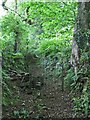
Gate in the footpath
A kissing gate gives access to this little used green lane which leads north from the B4308 Cwmbach Road to Bwlchfedwen Farm.
Image: © Richard Dorrell
Taken: 17 Jun 2013
0.25 miles