IMAGES TAKEN NEAR TO
Stradey Park, LLANELLI, SA15 4BT
Introduction
This page details the photographs taken nearby to Stradey Park, SA15 4BT by members of the Geograph project.
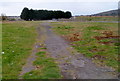
The Geograph project started in 2005 with the aim of publishing, organising and preserving representative images for every square kilometre of Great Britain, Ireland and the Isle of Man.

There are currently over 7.5m images from over14,400 individuals and you can help contribute to the project by visiting https://www.geograph.org.uk
Image Map
Images are licensed for reuse under creativecommons.org/licenses/by-sa/2.0
Notes
- Clicking on the map will re-center to the selected point.
- The higher the marker number, the further away the image location is from the centre of the postcode.
Image Listing (18 Images Found)
Images are licensed for reuse under creativecommons.org/licenses/by-sa/2.0
Image
Details
Distance
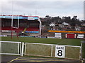
1
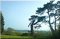
Views over Stradey Park
From St Margaret's Drive.
Image: © Deborah Tilley
Taken: 18 Apr 2009
0.07 miles
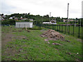
2
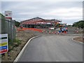
New building for Furnace Primary School
Under construction by Atkins, on behalf of Carmarthen County Council, and due to open in Spring 2015, this is the skeleton of the new Furnace Welsh Medium Primary School. The new school will replace the existing school, which is located close by, and is currently housed in one old building (which will be retained and converted into a house) and several temporary classrooms. The view here is from an entrance from Denham Avenue.
Image: © Richard Dorrell
Taken: 17 Jun 2013
0.08 miles
3
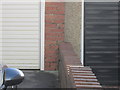
Ordnance Survey Cut Mark
This OS cut mark can be found on the garage of No78 Denham Avenue. It marks a point 9.6286m above mean sea level.
Image: © Adrian Dust
Taken: 15 Jan 2015
0.10 miles
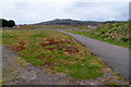
4
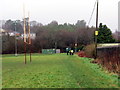
Cae Rygbi Ffwrnais / Furnace Rugby Field
Cerddwyr yn croesi cae rygbi Ffwrnais.
Walkers crossing Furnace rugby field.
Image: © Alan Richards
Taken: 28 Jan 2018
0.11 miles
5
Llanelli Scarlets at Stradey Park
Will this be the home of Llanelli Rugby for much longer?
Image: © Ronald John Saunders
Taken: 27 Jan 2007
0.13 miles
6
Furnace Primary School
The buildings closest to the camera are the scattered parts of the present Furness Welsh Medium Primary School. Construction of a fine new building for the school is underway nearby (see Image]). The old school building (with inverted 'V' gable end facing the camera) will be converted into housing, and the temporary classrooms removed.
Image: © Richard Dorrell
Taken: 17 Jun 2013
0.14 miles
7
Eastern side of the former Stradey Park rugby ground, Llanelli
Viewed from the western end of Stradey Park Avenue. The distant bank is the edge of the disused Stradey Park, formerly the home ground of Llanelli Rugby Football Club, who moved to Parc y Scarlets http://www.geograph.org.uk/photo/1043074 in the Pemberton area of the town in November 2008.
Image: © Jaggery
Taken: 8 Apr 2012
0.14 miles
8
Stradey Park, Llanelli
How long will this be Llanelli's home ground?
Image: © Ronald John Saunders
Taken: 27 Jan 2007
0.15 miles
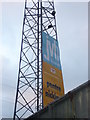
9

Scarlets Home Ground
Back of the famous 9-3 (Llanelli-Seland Newydd) scoreboard!
Image: © Ronald John Saunders
Taken: 27 Jan 2007
0.16 miles
10
Looking towards the SE corner of the former Stradey Park rugby ground, Llanelli
Viewed from the western end of Stradey Park Avenue. Stradey Park used to be the home ground of Llanelli Rugby Football Club, who moved to Parc y Scarlets http://www.geograph.org.uk/photo/1043074 in the Pemberton area of the town in November 2008.
Image: © Jaggery
Taken: 8 Apr 2012
0.16 miles