IMAGES TAKEN NEAR TO
Pwll Road, LLANELLI, SA15 4BD
Introduction
This page details the photographs taken nearby to Pwll Road, SA15 4BD by members of the Geograph project.
The Geograph project started in 2005 with the aim of publishing, organising and preserving representative images for every square kilometre of Great Britain, Ireland and the Isle of Man.

There are currently over 7.5m images from over14,400 individuals and you can help contribute to the project by visiting https://www.geograph.org.uk
Image Map
Images are licensed for reuse under creativecommons.org/licenses/by-sa/2.0
Notes
- Clicking on the map will re-center to the selected point.
- The higher the marker number, the further away the image location is from the centre of the postcode.
Image Listing (69 Images Found)
Images are licensed for reuse under creativecommons.org/licenses/by-sa/2.0
Image
Details
Distance
1
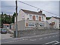
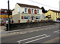
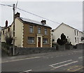
The Colliers Arms, Pwll
Located in Pwll Road. A sign on the building reads: 'A Traditional Pub', though the building looks more like a traditional detached house to me. I am sure it is 'pub-like' inside.
Image: © Richard Dorrell
Taken: 17 Jun 2013
0.00 miles
2
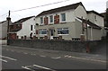
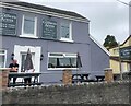
Colliers Arms, Pwll, Carmarthenshire
Traditional pub at 77 Pwll Road.
Image: © Jaggery
Taken: 22 Mar 2018
0.02 miles
3
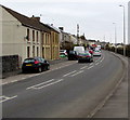
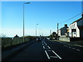
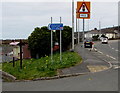
East along the A484 Pwll Road, Pwll, Carmarthenshire
The main road through the village. Ahead for Llanelli, behind the camera for Burry Port.
Image: © Jaggery
Taken: 22 Mar 2018
0.02 miles
5
Colliers Arms, 77 Pwll Road, Pwll, Carmarthenshire
One of the boards on the pub wall shows "a traditional pub".
Image: © Jaggery
Taken: 22 Mar 2018
0.02 miles
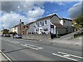
6
Collier's Arms
Beside the A484 at Pwll
Image: © Eirian Evans
Taken: 22 May 2022
0.03 miles
8
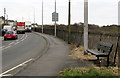
Roadside bench, Pwll, Carmarthenshire
On the south side of the A484 Pwll Road, the main road through the village.
Image: © Jaggery
Taken: 22 Mar 2018
0.05 miles
9
Rooftop solar panels, Pwll Road, Pwll, Carmarthenshire
Ideally located on a south-facing roof.
Image: © Jaggery
Taken: 22 Mar 2018
0.06 miles
10
This way to the Coastal Path, Pwll, Carmarthenshire
The sign is on the south side of the A484 Pwll Road, the main road through the village. The sign shows that Coastal Path is Llwybr Arfordirol in Welsh. The number 4 indicates National Cycle Network Route 4.
Image: © Jaggery
Taken: 22 Mar 2018
0.06 miles