IMAGES TAKEN NEAR TO
Maes Yr Haf, LLANELLI, SA15 4AT
Introduction
This page details the photographs taken nearby to Maes Yr Haf, SA15 4AT by members of the Geograph project.
The Geograph project started in 2005 with the aim of publishing, organising and preserving representative images for every square kilometre of Great Britain, Ireland and the Isle of Man.

There are currently over 7.5m images from over14,400 individuals and you can help contribute to the project by visiting https://www.geograph.org.uk
Image Map (Loading...)


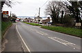
Getting Data...Please wait
Leaflet Map data © OpenStreetMap
Images are licensed for reuse under creativecommons.org/licenses/by-sa/2.0
Notes
- Clicking on the map will re-center to the selected point.
- The higher the marker number, the further away the image location is from the centre of the postcode.
Image Listing (38 Images Found)
Images are licensed for reuse under creativecommons.org/licenses/by-sa/2.0
Image
Details
Distance
1
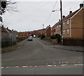
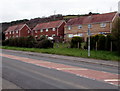
Western arm of Maesyrhaf, Pwll, Carmarthenshire
Houses on the dead-end west side of the main through route of Maesyrhaf.
Image: © Jaggery
Taken: 22 Mar 2018
0.04 miles
2
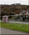
Dissimilar bus shelters alongside the A484 Pwll Road, Pwll, Carmarthenshire
Alongside the stop for buses to Carmarthen via Burry Port and Pembrey, the shelter on the left is of a type and colour common in Carmarthenshire. The other shelter is for buses to Llanelli and Swansea.
Image: © Jaggery
Taken: 22 Mar 2018
0.05 miles
3
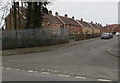
Maesyrhaf houses, Pwll, Carmarthenshire
Houses on the dead-end west side of the main through route of Maesyrhaf.
Image: © Jaggery
Taken: 22 Mar 2018
0.05 miles
4
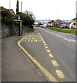
Bus stop and shelter in the west of Pwll, Carmarthenshire
This stop alongside the A484 Pwll Road is for buses to Llanelli and Swansea.
Image: © Jaggery
Taken: 22 Mar 2018
0.06 miles
5
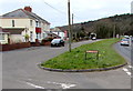
Maesyrhaf semis, Pwll, Carmarthenshire
The back gardens and backs of semi-detached houses in Maesyrhaf,
viewed across the A484 Pwll Road, the main road through the village.
Image: © Jaggery
Taken: 22 Mar 2018
0.06 miles
6
Tyrwaun, Pwll, Carmarthenshire
Houses set back from the A484 Pwll Road, the main road through the village.
Image: © Jaggery
Taken: 22 Mar 2018
0.07 miles
7
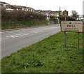
Western boundary of Pwll, Carmarthenshire
The A484 Pwll Road from Burry Port reaches the village of Pwll.
Image: © Jaggery
Taken: 22 Mar 2018
0.07 miles
8
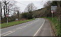
End of the 30 zone through Pwll, Carmarthenshire
Beyond the western edge of the village, the speed limit on the A484 Pwll Road towards Burry Port
increases to 40mph. The grey back of the Pwll boundary sign https://www.geograph.org.uk/photo/5714131 is on the left.
Image: © Jaggery
Taken: 22 Mar 2018
0.07 miles
9
Start of the 30 zone at the western edge of Pwll, Carmarthenshire
The 40mph speed limit on the A484 from Burry Port drops to 30mph.
The Pwll boundary sign https://www.geograph.org.uk/photo/5714131 is on the right.
Image: © Jaggery
Taken: 22 Mar 2018
0.07 miles
10
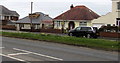
Tyrwaun bungalows, Pwll, Carmarthenshire
Set back from the south side of the A484 Pwll Road, the main road through the village.
Originally, bungalow was used in English for a lightly-built house, with a veranda and one storey.
In current UK usage it is a convenient word for any one-storey dwelling.
Image: © Jaggery
Taken: 22 Mar 2018
0.08 miles