IMAGES TAKEN NEAR TO
Stepney Road, LLANELLI, SA15 4AA
Introduction
This page details the photographs taken nearby to Stepney Road, SA15 4AA by members of the Geograph project.
The Geograph project started in 2005 with the aim of publishing, organising and preserving representative images for every square kilometre of Great Britain, Ireland and the Isle of Man.

There are currently over 7.5m images from over14,400 individuals and you can help contribute to the project by visiting https://www.geograph.org.uk
Image Map (Loading...)


Getting Data...Please wait
Leaflet Map data © OpenStreetMap
Images are licensed for reuse under creativecommons.org/licenses/by-sa/2.0
Notes
- Clicking on the map will re-center to the selected point.
- The higher the marker number, the further away the image location is from the centre of the postcode.
Image Listing (42 Images Found)
Images are licensed for reuse under creativecommons.org/licenses/by-sa/2.0
Image
Details
Distance
1

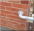
Ordnance Survey Cut Mark
This OS cut mark can be found on the wall of No29 Stepney Road. It marks a point 10.833m above mean sea level.
Image: © Adrian Dust
Taken: 22 Jan 2020
0.05 miles
2
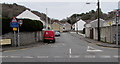
Stepney Road, Pwll, Carmarthenshire
From the north side of the A484 Bassett Terrace, Stepney Road leads to The Nurseries and Stradey Hill.
The blue sign on the left shows that the route ahead is unsuitable for long vehicles. The text is also in Welsh.
Image: © Jaggery
Taken: 22 Mar 2018
0.07 miles
3
Ordnance Survey Cut Mark
This OS cut mark can be found on the west face of the school. It marks a point 8.9093m above mean sea level.
Image: © Adrian Dust
Taken: 22 Jan 2020
0.09 miles
4
Y Bryngwyn Newydd, Pwll, Carmarthenshire
Pub & steakhouse at 8 Bassett Terrace. Formerly named Tafarn y Sospan.
Image: © Jaggery
Taken: 22 Mar 2018
0.11 miles
5
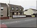
Y Bryngwyn Newydd, Pwll
A family run steakhouse located on the A484, Bassett Terrace, between Pwll and Llanelli.
Image: © Richard Dorrell
Taken: 17 Jun 2013
0.11 miles
6
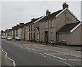
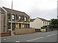
Bassett Terrace houses, Pwll, Carmarthenshire
Here named Bassett Terrace, the A484 is the main road through the village.
Image: © Jaggery
Taken: 22 Mar 2018
0.12 miles
7
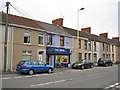
Pwll Stores, Bassett Terrace, Pwll, Carmarthenshire
Convenience store opposite Stepney Road.
Image: © Jaggery
Taken: 22 Mar 2018
0.12 miles
8
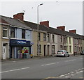
Pwll Stores
Small general store located in Bassett Terrace opposite the junction with Stepney Road.
Image: © Richard Dorrell
Taken: 17 Jun 2013
0.13 miles
9
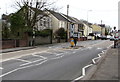
Zebra crossing, Bassett Terrace, Pwll, Carmarthenshire
Across the A484 here named Bassett Terrace. Although Belisha beacons had marked pedestrian crossings in the UK from 1934, it was not until 1951 that the now familiar black and white stripes stretching across the width of the road were officially introduced. Previously, there were only metal studs across the road surface
Image: © Jaggery
Taken: 22 Mar 2018
0.13 miles
10
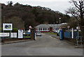
Entrance to Graig Campus, Coleg Sir G?r, Llanelli
From the north side of the A484 Sandy Road. Maximum speed 5mph.
The campus exit https://www.geograph.org.uk/photo/5718681 is 130 metres to the right (east).
Coleg Sir Gâr is Welsh for Carmarthenshire College.
Image: © Jaggery
Taken: 22 Mar 2018
0.13 miles